Cotaparaco elevation
Cotaparaco (Ancash, Provincia de Recuay), Peru elevation is 3296 meters and Cotaparaco elevation in feet is 10814 ft above sea level [src 1]. Cotaparaco is a seat of a third-order administrative division (feature code) with elevation that is 975 meters (3199 ft) bigger than average city elevation in Peru.
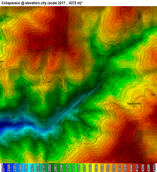
Below is the Elevation map of Cotaparaco, which displays elevation range with different colors. Scale of the first map is from 2217 to 4372 m (7274 to 14344 ft) with average elevation of 3489.6 meters (=11449 ft) [note 1]
These maps also provides idea of topography and contour of this city, they are displayed at different zoom levels. More info about maps, scale and edge coordinates you can find below images.
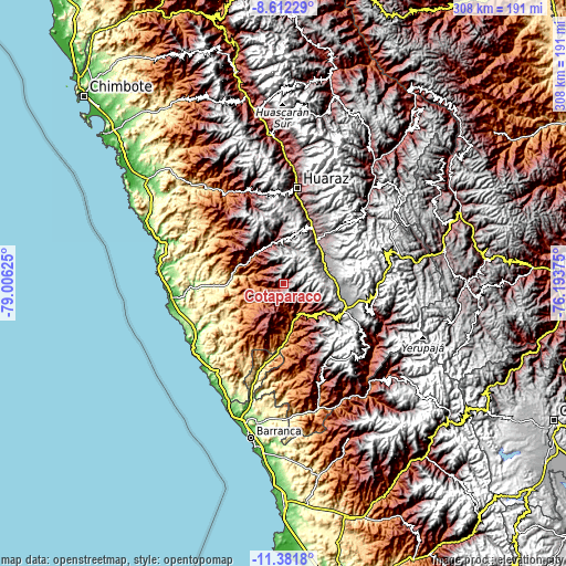
| \ | Map #1 | Topo.Map |
| Scale [m] | 2217..4372 m | × |
| Scale [ft] | 7274..14344 ft | × |
| Average | 3489.6 m = 11449 ft | × |
| Width | 9.62 km = 6 mi | 307.9 km = 191.3 mi |
| Height | 9.62 km = 6 mi | 308 km = 191.4 mi |
| ↑Max Latitude | -9.956719° | -8.61229° |
| Latitude at center | -10° | -10° |
| ↓Min Latitude | -10.043275° | -11.3818° |
| ← Min Longitude | -77.643945° | -79.00625° |
| Longitude center | -77.6° | -77.6° |
| →Max Longitude | -77.556055° | -76.19375° |
Nearby cities:
Cities around Cotaparaco sort by population:
• La Merced elevation 3289 m
29.5 km,  356°
356°
• Catac 3541 m
28.8 km,  39°
39°
• Pampas Chico 3538 m
25.6 km,  120°
120°
• Coris 2448 m
24.8 km,  318°
318°
• Cajacay 2613 m
24.6 km,  134°
134°
• Aija 3409 m
24.4 km, 357°
• Succha 3554 m
19.3 km,  343°
343°
• Marca 2635 m
16.9 km, 125°
• Malvas 2680 m
13 km, 315°
• Huayllapampa 3191 m
9.2 km, 127°
• Llacllin 3116 m
7.6 km,  193°
193°
• Tapacocha 3480 m
2.6 km,  135°
135°
Multilingual:
 En español:
Cotaparaco elevación 3296 m.
 En France:
Cotaparaco élévation 3296 m.
 Auf Deutsch:
Cotaparaco höhe über dem Meeresspiegel ist 3296 m.

Sources and notes:
- [note 1] Map square and city borders are not equal. Map elevation data is calculated only from area inside that square.
- [src 1] Elevation data from geonames database provided with same terms of usage.
- [src 2] The elevation map of Cotaparaco is generated using elevation data from NASA's 3 arcsec (90m) resolution SRTM data.
- [src 3] Base (background) map © OpenStreetMap contributors tiles are generated by Geofabrik and OpenTopoMap.
Copyright & License:
This Cotaparaco Elevation Map is licensed under CC BY-SA. You may reuse any part from this page, if you give a proper credit by linking to this URL:
 More info on terms of use page.