Huayllay elevation
Huayllay (Pasco, Provincia de Pasco), Peru elevation is 4320 meters and Huayllay elevation in feet is 14173 ft above sea level [src 1]. Huayllay is a seat of a third-order administrative division (feature code) with elevation that is 1999 meters (6558 ft) bigger than average city elevation in Peru.
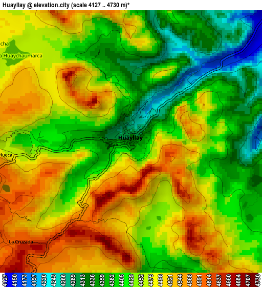
Below is the Elevation map of Huayllay, which displays elevation range with different colors. Scale of the first map is from 4127 to 4730 m (13540 to 15518 ft) with average elevation of 4447 meters (=14590 ft) [note 1]
These maps also provides idea of topography and contour of this city, they are displayed at different zoom levels. More info about maps, scale and edge coordinates you can find below images.
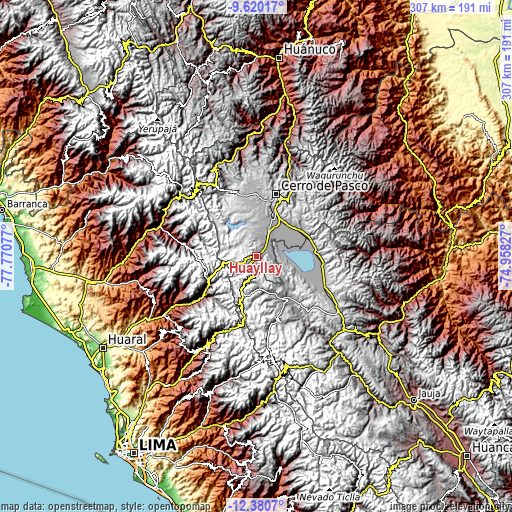
| \ | Map #1 | Topo.Map |
| Scale [m] | 4127..4730 m | × |
| Scale [ft] | 13540..15518 ft | × |
| Average | 4447 m = 14590 ft | × |
| Width | 9.59 km = 6 mi | 306.9 km = 190.7 mi |
| Height | 9.59 km = 6 mi | 307 km = 190.8 mi |
| ↑Max Latitude | -10.960529° | -9.62017° |
| Latitude at center | -11.00367° | -11.00367° |
| ↓Min Latitude | -11.046804° | -12.3807° |
| ← Min Longitude | -76.408465° | -77.77077° |
| Longitude center | -76.36452° | -76.36452° |
| →Max Longitude | -76.320575° | -74.95827° |
Nearby cities:
Cities around Huayllay sort by population:
• Cerro de Pasco elevation 4336 m
39.2 km,  17°
17°
• Junín 4117 m
44.1 km,  113°
113°
• Carhuamayo 4263 m
37.4 km,  75°
75°
• Tinyahuarco 4253 m
28 km, 20°
• Huaros 3586 m
50.4 km,  207°
207°
• Carac 2615 m
50 km,  245°
245°
• Marcapomacocha 4418 m
44.9 km,  176°
176°
• Jucul 3553 m
42 km,  278°
278°
• Pirca 3265 m
40.8 km,  231°
231°
• Pacaraos 3334 m
36.9 km,  236°
236°
• Ninacaca 4189 m
32 km,  57°
57°
• Ondores 4099 m
25.3 km, 111°
Multilingual:
 En español:
Huayllay elevación 4320 m.
 En France:
Huayllay élévation 4320 m.
 Auf Deutsch:
Huayllay höhe über dem Meeresspiegel ist 4320 m.

Sources and notes:
- [note 1] Map square and city borders are not equal. Map elevation data is calculated only from area inside that square.
- [src 1] Elevation data from geonames database provided with same terms of usage.
- [src 2] The elevation map of Huayllay is generated using elevation data from NASA's 3 arcsec (90m) resolution SRTM data.
- [src 3] Base (background) map © OpenStreetMap contributors tiles are generated by Geofabrik and OpenTopoMap.
Copyright & License:
This Huayllay Elevation Map is licensed under CC BY-SA. You may reuse any part from this page, if you give a proper credit by linking to this URL:
 More info on terms of use page.