Carac elevation
Carac (Lima region, Provincia de Huaral), Peru elevation is 2615 meters and Carac elevation in feet is 8579 ft above sea level [src 1]. Carac is a seat of a third-order administrative division (feature code) with elevation that is 294 meters (965 ft) bigger than average city elevation in Peru.
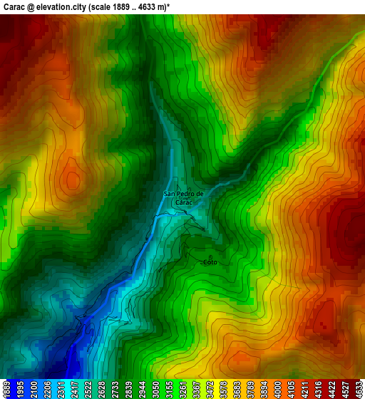
Below is the Elevation map of Carac, which displays elevation range with different colors. Scale of the first map is from 1889 to 4633 m (6198 to 15200 ft) with average elevation of 3341.7 meters (=10964 ft) [note 1]
These maps also provides idea of topography and contour of this city, they are displayed at different zoom levels. More info about maps, scale and edge coordinates you can find below images.
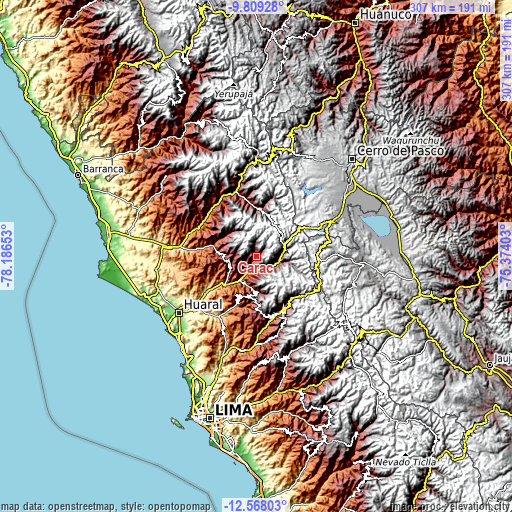
| \ | Map #1 | Topo.Map |
| Scale [m] | 1889..4633 m | × |
| Scale [ft] | 6198..15200 ft | × |
| Average | 3341.7 m = 10964 ft | × |
| Width | 9.59 km = 6 mi | 306.7 km = 190.6 mi |
| Height | 9.59 km = 6 mi | 306.8 km = 190.6 mi |
| ↑Max Latitude | -11.148827° | -9.80928° |
| Latitude at center | -11.19194° | -11.19194° |
| ↓Min Latitude | -11.235046° | -12.56803° |
| ← Min Longitude | -76.824225° | -78.18653° |
| Longitude center | -76.78028° | -76.78028° |
| →Max Longitude | -76.736335° | -75.37403° |
Nearby cities:
Cities around Carac sort by population:
• Huamantanga elevation 3389 m
34.3 km,  174°
174°
• Huaros 3586 m
32.5 km,  137°
137°
• Paccho 3259 m
30.9 km,  327°
327°
• Maray 3695 m
29.1 km,  348°
348°
• Jucul 3553 m
27.3 km,  8°
8°
• Sumbilca 3367 m
24.4 km,  190°
190°
• Santa Cruz 3277 m
22 km,  311°
311°
• Ihuari 2828 m
18.7 km,  270°
270°
• Pacaraos 3334 m
14.5 km,  87°
87°
• Pirca 3265 m
14.4 km,  109°
109°
• Acos 1583 m
10.1 km,  205°
205°
• Lampian 2433 m
8.2 km,  231°
231°
Multilingual:
 En español:
Carac elevación 2615 m.
 En France:
Carac élévation 2615 m.


Sources and notes:
- [note 1] Map square and city borders are not equal. Map elevation data is calculated only from area inside that square.
- [src 1] Elevation data from geonames database provided with same terms of usage.
- [src 2] The elevation map of Carac is generated using elevation data from NASA's 3 arcsec (90m) resolution SRTM data.
- [src 3] Base (background) map © OpenStreetMap contributors tiles are generated by Geofabrik and OpenTopoMap.
Copyright & License:
This Carac Elevation Map is licensed under CC BY-SA. You may reuse any part from this page, if you give a proper credit by linking to this URL:
 More info on terms of use page.