Ichuña elevation
Ichuña (Moquegua, Provincia de General Sánchez Cerro), Peru elevation is 3755 meters and Ichuña elevation in feet is 12320 ft above sea level [src 1]. Ichuña is a seat of a third-order administrative division (feature code) with elevation that is 1434 meters (4705 ft) bigger than average city elevation in Peru.
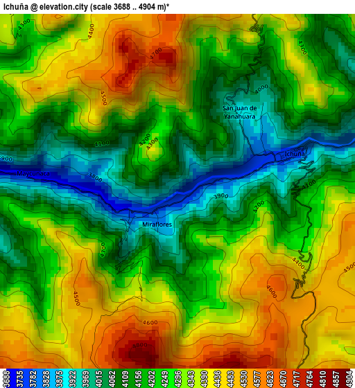
Below is the Elevation map of Ichuña, which displays elevation range with different colors. Scale of the first map is from 3688 to 4904 m (12100 to 16089 ft) with average elevation of 4267.6 meters (=14001 ft) [note 1]
These maps also provides idea of topography and contour of this city, they are displayed at different zoom levels. More info about maps, scale and edge coordinates you can find below images.
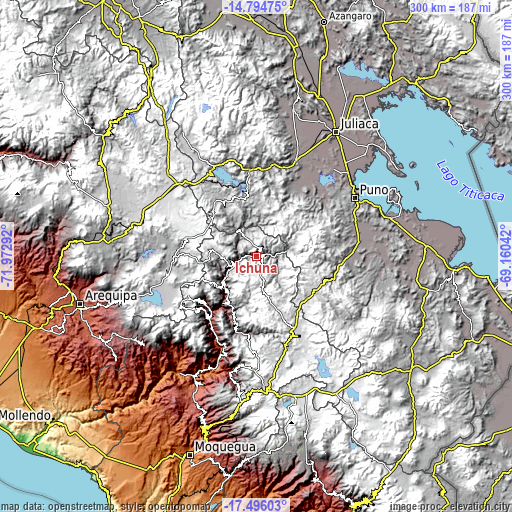
| \ | Map #1 | Topo.Map |
| Scale [m] | 3688..4904 m | × |
| Scale [ft] | 12100..16089 ft | × |
| Average | 4267.6 m = 14001 ft | × |
| Width | 9.39 km = 5.8 mi | 300.4 km = 186.7 mi |
| Height | 9.39 km = 5.8 mi | 300.4 km = 186.7 mi |
| ↑Max Latitude | -16.107784° | -14.79475° |
| Latitude at center | -16.15° | -16.15° |
| ↓Min Latitude | -16.192207° | -17.49603° |
| ← Min Longitude | -70.610615° | -71.97292° |
| Longitude center | -70.56667° | -70.56667° |
| →Max Longitude | -70.522725° | -69.16042° |
Nearby cities:
Cities around Ichuña sort by population:
• Hacienda Huancane elevation 4531 m
49.8 km,  316°
316°
• Santa Lucía 4046 m
50.4 km,  355°
355°
• Laraqueri 3935 m
55.2 km,  88°
88°
• Vilque 3845 m
54.4 km,  38°
38°
• Tiquillaca 3855 m
53.9 km,  46°
46°
• Tarucani 4243 m
53.5 km,  266°
266°
• Mañazo 3918 m
46.2 km,  32°
32°
• Matalaque 2761 m
45.7 km,  215°
215°
• Ubinas 3483 m
42.4 km,  229°
229°
• Chojata 4165 m
33 km,  212°
212°
• Lloque 3554 m
27.1 km, 221°
• Yunga 3780 m
13.6 km,  245°
245°
Multilingual:
 En español:
Ichuña elevación 3755 m.
 En France:
Ichuña élévation 3755 m.


Sources and notes:
- [note 1] Map square and city borders are not equal. Map elevation data is calculated only from area inside that square.
- [src 1] Elevation data from geonames database provided with same terms of usage.
- [src 2] The elevation map of Ichuña is generated using elevation data from NASA's 3 arcsec (90m) resolution SRTM data.
- [src 3] Base (background) map © OpenStreetMap contributors tiles are generated by Geofabrik and OpenTopoMap.
Copyright & License:
This Ichuña Elevation Map is licensed under CC BY-SA. You may reuse any part from this page, if you give a proper credit by linking to this URL:
 More info on terms of use page.