Tarucani elevation
Tarucani (Arequipa, Provincia de Arequipa), Peru elevation is 4243 meters and Tarucani elevation in feet is 13921 ft above sea level [src 1]. Tarucani is a seat of a third-order administrative division (feature code) with elevation that is 1922 meters (6306 ft) bigger than average city elevation in Peru.
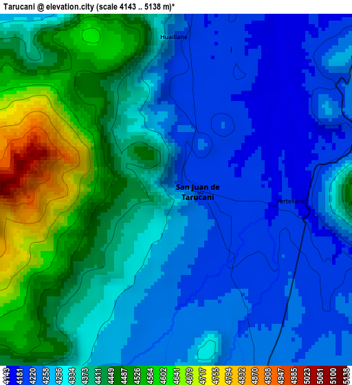
Below is the Elevation map of Tarucani, which displays elevation range with different colors. Scale of the first map is from 4143 to 5138 m (13593 to 16857 ft) with average elevation of 4349.6 meters (=14270 ft) [note 1]
These maps also provides idea of topography and contour of this city, they are displayed at different zoom levels. More info about maps, scale and edge coordinates you can find below images.
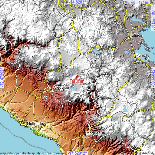
| \ | Map #1 | Topo.Map |
| Scale [m] | 4143..5138 m | × |
| Scale [ft] | 13593..16857 ft | × |
| Average | 4349.6 m = 14270 ft | × |
| Width | 9.39 km = 5.8 mi | 300.3 km = 186.6 mi |
| Height | 9.39 km = 5.8 mi | 300.3 km = 186.6 mi |
| ↑Max Latitude | -16.141122° | -14.8283° |
| Latitude at center | -16.18333° | -16.18333° |
| ↓Min Latitude | -16.225529° | -17.52912° |
| ← Min Longitude | -71.110615° | -72.47292° |
| Longitude center | -71.06667° | -71.06667° |
| →Max Longitude | -71.022725° | -69.66042° |
Nearby cities:
Cities around Tarucani sort by population:
• Hacienda Huancane elevation 4531 m
44.5 km,  25°
25°
• Vizcachane 4432 m
44.1 km,  340°
340°
• Pucara 4352 m
47.7 km,  298°
298°
• Coalaque 2276 m
52.2 km,  174°
174°
• Pocsi 3055 m
50.5 km,  222°
222°
• Puquina 3098 m
50.5 km,  194°
194°
• Chiguata 2947 m
43 km,  235°
235°
• Chojata 4165 m
43 km,  124°
124°
• Matalaque 2761 m
42.7 km,  141°
141°
• Yunga 3780 m
41 km,  92°
92°
• Lloque 3554 m
39.3 km, 115°
• Ubinas 3483 m
32.2 km, 138°
Multilingual:
 En español:
Tarucani elevación 4243 m.
 En France:
Tarucani élévation 4243 m.
 Auf Deutsch:
Tarucani höhe über dem Meeresspiegel ist 4243 m.

Sources and notes:
- [note 1] Map square and city borders are not equal. Map elevation data is calculated only from area inside that square.
- [src 1] Elevation data from geonames database provided with same terms of usage.
- [src 2] The elevation map of Tarucani is generated using elevation data from NASA's 3 arcsec (90m) resolution SRTM data.
- [src 3] Base (background) map © OpenStreetMap contributors tiles are generated by Geofabrik and OpenTopoMap.
Copyright & License:
This Tarucani Elevation Map is licensed under CC BY-SA. You may reuse any part from this page, if you give a proper credit by linking to this URL:
 More info on terms of use page.