Ichupampa elevation
Ichupampa (Arequipa, Provincia de Caylloma), Peru elevation is 3405 meters and Ichupampa elevation in feet is 11171 ft above sea level [src 1]. Ichupampa is a seat of a third-order administrative division (feature code) with elevation that is 1084 meters (3556 ft) bigger than average city elevation in Peru.
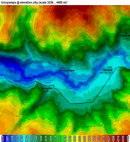
Below is the Elevation map of Ichupampa, which displays elevation range with different colors. Scale of the first map is from 3236 to 4400 m (10617 to 14436 ft) with average elevation of 3717.4 meters (=12196 ft) [note 1]
These maps also provides idea of topography and contour of this city, they are displayed at different zoom levels. More info about maps, scale and edge coordinates you can find below images.
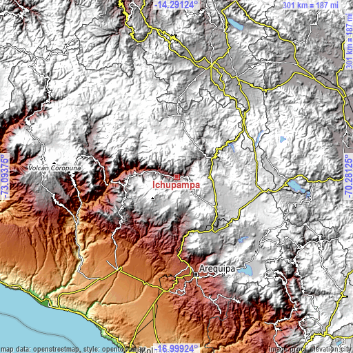
| \ | Map #1 | Topo.Map |
| Scale [m] | 3236..4400 m | × |
| Scale [ft] | 10617..14436 ft | × |
| Average | 3717.4 m = 12196 ft | × |
| Width | 9.41 km = 5.8 mi | 301.1 km = 187.1 mi |
| Height | 9.41 km = 5.8 mi | 301.1 km = 187.1 mi |
| ↑Max Latitude | -15.607399° | -14.29124° |
| Latitude at center | -15.64972° | -15.64972° |
| ↓Min Latitude | -15.692032° | -16.99924° |
| ← Min Longitude | -71.731445° | -73.09375° |
| Longitude center | -71.6875° | -71.6875° |
| →Max Longitude | -71.643555° | -70.28125° |
Nearby cities:
Cities around Ichupampa sort by population:
• Huarancante elevation 4587 m
27.7 km,  118°
118°
• Chivay 3639 m
9.3 km,  82°
82°
• Ccolo 3860 m
26.3 km,  52°
52°
• Callalli 3878 m
30.3 km,  58°
58°
• Tapay 2989 m
28.1 km,  286°
286°
• Tuti 3802 m
19.6 km, 48°
• Madrigal 3279 m
13.7 km, 289°
• Lari 3356 m
9.2 km, 289°
• Maca 3276 m
8.8 km,  275°
275°
• Coporaque 3583 m
5.1 km, 60°
• Yanque 3431 m
3.2 km,  88°
88°
• Achoma 3488 m
1.9 km,  229°
229°
Multilingual:
 En español:
Ichupampa elevación 3405 m.
 En France:
Ichupampa élévation 3405 m.
 Auf Deutsch:
Ichupampa höhe über dem Meeresspiegel ist 3405 m.

Sources and notes:
- [note 1] Map square and city borders are not equal. Map elevation data is calculated only from area inside that square.
- [src 1] Elevation data from geonames database provided with same terms of usage.
- [src 2] The elevation map of Ichupampa is generated using elevation data from NASA's 3 arcsec (90m) resolution SRTM data.
- [src 3] Base (background) map © OpenStreetMap contributors tiles are generated by Geofabrik and OpenTopoMap.
Copyright & License:
This Ichupampa Elevation Map is licensed under CC BY-SA. You may reuse any part from this page, if you give a proper credit by linking to this URL:
 More info on terms of use page.