Macusani elevation
Macusani (Puno, Provincia de Carabaya), Peru elevation is 4360 meters and Macusani elevation in feet is 14304 ft above sea level [src 1]. Macusani is a seat of a third-order administrative division (feature code) with elevation that is 2039 meters (6690 ft) bigger than average city elevation in Peru.
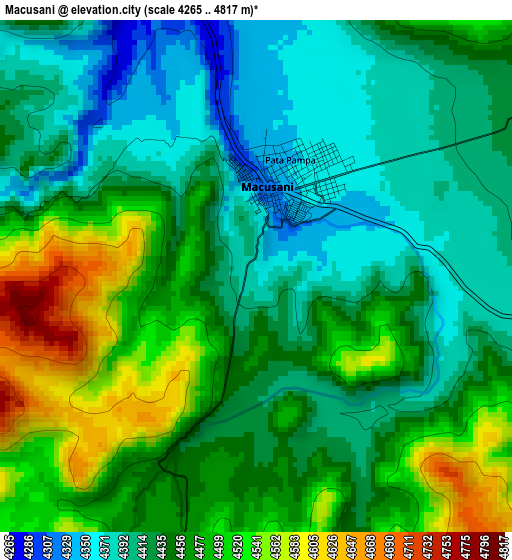
Below is the Elevation map of Macusani, which displays elevation range with different colors. Scale of the first map is from 4265 to 4817 m (13993 to 15804 ft) with average elevation of 4450.8 meters (=14602 ft) [note 1]
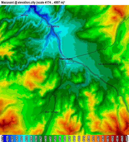
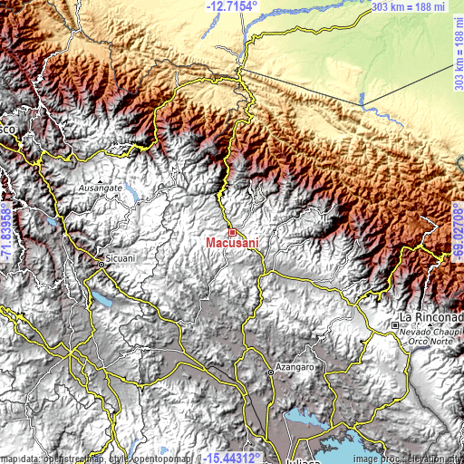
These maps also provides idea of topography and contour of this city, they are displayed at different zoom levels. More info about maps, scale and edge coordinates you can find below images.
| \ | Map #1 | Map #2 | Topo.Map |
| Scale [m] | 4265..4817 m | 4174..4997 m | × |
| Scale [ft] | 13993..15804 ft | 13694..16394 ft | × |
| Average | 4450.8 m = 14602 ft | 4523.5 m = 14841 ft | × |
| Width | 9.48 km = 5.9 mi | 18.96 km = 11.8 mi | 303.3 km = 188.5 mi |
| Height | 9.48 km = 5.9 mi | 18.96 km = 11.8 mi | 303.3 km = 188.5 mi |
| ↑Max Latitude | -14.040702° | -13.998065° | -12.7154° |
| Latitude at center | -14.08333° | -14.08333° | -14.08333° |
| ↓Min Latitude | -14.12595° | -14.168563° | -15.44312° |
| ← Min Longitude | -70.477275° | -70.521221° | -71.83958° |
| Longitude center | -70.43333° | -70.43333° | -70.43333° |
| →Max Longitude | -70.389385° | -70.345439° | -69.02708° |
Nearby cities:
Cities around Macusani sort by population:
• Ñuñoa elevation 4022 m
49 km,  206°
206°
• Orurillo 3954 m
72.4 km,  186°
186°
• Santa Rosa 3980 m
69.9 km, 212°
• Lanlacuni Bajo 707 m
66.7 km,  1°
1°
• Crucero 4213 m
55.3 km,  122°
122°
• Coasa 4430 m
51.2 km,  79°
79°
• Usicayos 3780 m
50.6 km,  95°
95°
• Potoni 4174 m
50.4 km,  131°
131°
• Antauta 4775 m
35.9 km,  168°
168°
• Ollachea 2907 m
30.1 km,  349°
349°
• Corani 4201 m
30.1 km,  321°
321°
• Ajoyani 4632 m
25.2 km,  94°
94°
Multilingual:
 En español:
Macusani elevación 4360 m.
 En France:
Macusani élévation 4360 m.
 Auf Deutsch:
Macusani höhe über dem Meeresspiegel ist 4360 m.

Sources and notes:
- [note 1] Map square and city borders are not equal. Map elevation data is calculated only from area inside that square.
- [src 1] Elevation data from geonames database provided with same terms of usage.
- [src 2] The elevation map of Macusani is generated using elevation data from NASA's 3 arcsec (90m) resolution SRTM data.
- [src 3] Base (background) map © OpenStreetMap contributors tiles are generated by Geofabrik and OpenTopoMap.
Copyright & License:
This Macusani Elevation Map is licensed under CC BY-SA. You may reuse any part from this page, if you give a proper credit by linking to this URL:
 More info on terms of use page.