Ñuñoa elevation
Ñuñoa (Puno, Provincia de Melgar), Peru elevation is 4022 meters and Ñuñoa elevation in feet is 13196 ft above sea level [src 1]. Ñuñoa is a populated place (feature code) with elevation that is 1701 meters (5581 ft) bigger than average city elevation in Peru.
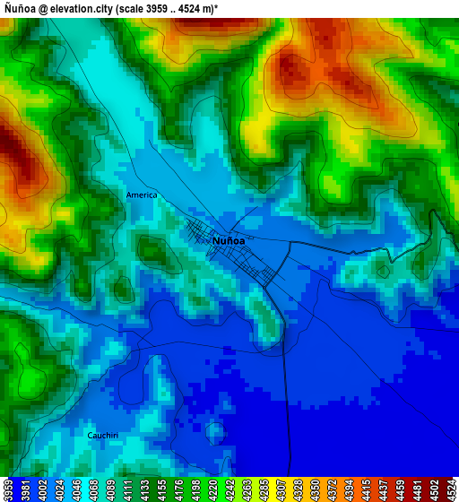
Below is the Elevation map of Ñuñoa, which displays elevation range with different colors. Scale of the first map is from 3959 to 4524 m (12989 to 14843 ft) with average elevation of 4108.3 meters (=13479 ft) [note 1]
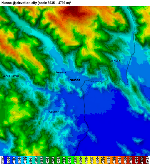
These maps also provides idea of topography and contour of this city, they are displayed at different zoom levels. More info about maps, scale and edge coordinates you can find below images.
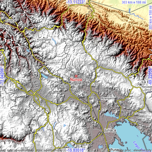
| \ | Map #1 | Map #2 | Topo.Map |
| Scale [m] | 3959..4524 m | 3935..4799 m | × |
| Scale [ft] | 12989..14843 ft | 12910..15745 ft | × |
| Average | 4108.3 m = 13479 ft | 4176.6 m = 13703 ft | × |
| Width | 9.46 km = 5.9 mi | 18.92 km = 11.8 mi | 302.8 km = 188.2 mi |
| Height | 9.46 km = 5.9 mi | 18.92 km = 11.8 mi | 302.8 km = 188.2 mi |
| ↑Max Latitude | -14.435326° | -14.392764° | -13.11223° |
| Latitude at center | -14.47788° | -14.47788° | -14.47788° |
| ↓Min Latitude | -14.520426° | -14.562963° | -15.83518° |
| ← Min Longitude | -70.679775° | -70.723721° | -72.04208° |
| Longitude center | -70.63583° | -70.63583° | -70.63583° |
| →Max Longitude | -70.591885° | -70.547939° | -69.22958° |
Nearby cities:
Cities around Ñuñoa sort by population:
• Ayaviri elevation 3898 m
45.7 km,  173°
173°
• Macusani 4360 m
49 km,  26°
26°
• Mosoc Cancha 4301 m
53.2 km,  293°
293°
• Huayna Alcalde 4149 m
54.7 km,  295°
295°
• Layo 3985 m
55.9 km,  268°
268°
• Cupi 4090 m
54.1 km,  208°
208°
• Asillo 3903 m
45.8 km,  137°
137°
• Umachiri 3924 m
44.1 km,  197°
197°
• Macari 3964 m
43.2 km,  221°
221°
• Orurillo 3954 m
31 km,  154°
154°
• Antauta 4775 m
30.2 km,  73°
73°
• Santa Rosa 3980 m
21.9 km,  227°
227°
Multilingual:
 En español:
Ñuñoa elevación 4022 m.
 En France:
Ñuñoa élévation 4022 m.


Sources and notes:
- [note 1] Map square and city borders are not equal. Map elevation data is calculated only from area inside that square.
- [src 1] Elevation data from geonames database provided with same terms of usage.
- [src 2] The elevation map of Ñuñoa is generated using elevation data from NASA's 3 arcsec (90m) resolution SRTM data.
- [src 3] Base (background) map © OpenStreetMap contributors tiles are generated by Geofabrik and OpenTopoMap.
Copyright & License:
This Ñuñoa Elevation Map is licensed under CC BY-SA. You may reuse any part from this page, if you give a proper credit by linking to this URL:
 More info on terms of use page.