Pomacocha elevation
Pomacocha (Apurímac, Provincia de Andahuaylas), Peru elevation is 3661 meters and Pomacocha elevation in feet is 12011 ft above sea level [src 1]. Pomacocha is a seat of a third-order administrative division (feature code) with elevation that is 1340 meters (4396 ft) bigger than average city elevation in Peru.
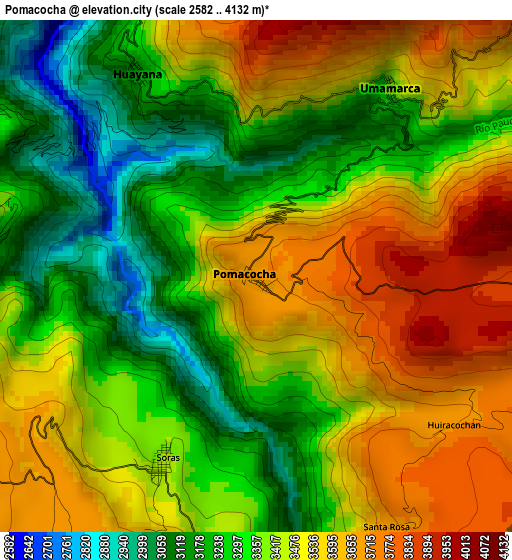
Below is the Elevation map of Pomacocha, which displays elevation range with different colors. Scale of the first map is from 2582 to 4132 m (8471 to 13556 ft) with average elevation of 3418.4 meters (=11215 ft) [note 1]
These maps also provides idea of topography and contour of this city, they are displayed at different zoom levels. More info about maps, scale and edge coordinates you can find below images.
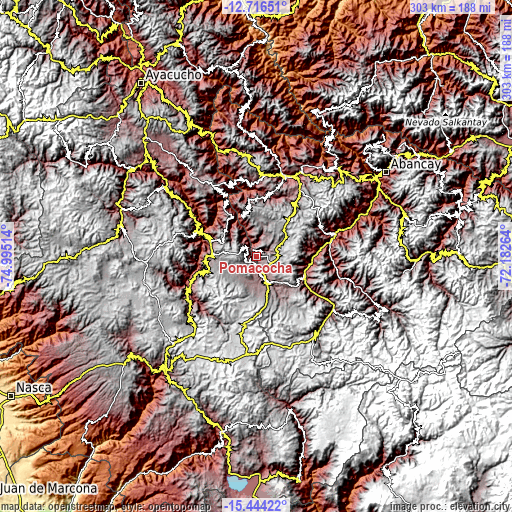
| \ | Map #1 | Topo.Map |
| Scale [m] | 2582..4132 m | × |
| Scale [ft] | 8471..13556 ft | × |
| Average | 3418.4 m = 11215 ft | × |
| Width | 9.48 km = 5.9 mi | 303.3 km = 188.5 mi |
| Height | 9.48 km = 5.9 mi | 303.3 km = 188.5 mi |
| ↑Max Latitude | -14.041812° | -12.71651° |
| Latitude at center | -14.08444° | -14.08444° |
| ↓Min Latitude | -14.12706° | -15.44422° |
| ← Min Longitude | -73.632835° | -74.99514° |
| Longitude center | -73.58889° | -73.58889° |
| →Max Longitude | -73.544945° | -72.18264° |
Nearby cities:
Cities around Pomacocha sort by population:
• Soraya elevation 2879 m
31 km,  106°
106°
• Morcolla 3493 m
30.6 km,  264°
264°
• Sañayca 3081 m
30.5 km,  116°
116°
• Capaya 3264 m
29.5 km,  97°
97°
• Querobamba 3512 m
28.2 km,  286°
286°
• Chiara 3326 m
25.5 km,  340°
340°
• Chaccrampa 3657 m
14 km,  351°
351°
• Pampachiri 3384 m
12.4 km,  156°
156°
• Paico 3086 m
7.9 km,  311°
311°
• Huayana 3207 m
4.6 km,  330°
330°
• Umamarca 3383 m
4.3 km,  35°
35°
• Soras 3424 m
3.8 km,  206°
206°
Multilingual:
 En español:
Pomacocha elevación 3661 m.
 En France:
Pomacocha élévation 3661 m.
 Auf Deutsch:
Pomacocha höhe über dem Meeresspiegel ist 3661 m.

Sources and notes:
- [note 1] Map square and city borders are not equal. Map elevation data is calculated only from area inside that square.
- [src 1] Elevation data from geonames database provided with same terms of usage.
- [src 2] The elevation map of Pomacocha is generated using elevation data from NASA's 3 arcsec (90m) resolution SRTM data.
- [src 3] Base (background) map © OpenStreetMap contributors tiles are generated by Geofabrik and OpenTopoMap.
Copyright & License:
This Pomacocha Elevation Map is licensed under CC BY-SA. You may reuse any part from this page, if you give a proper credit by linking to this URL:
 More info on terms of use page.