Punta de Bombón elevation
Punta de Bombón (Arequipa, Provincia de Islay), Peru elevation is 25 meters and Punta de Bombón elevation in feet is 82 ft above sea level [src 1]. Punta de Bombón is a populated place (feature code) with elevation that is 2296 meters (7533 ft) smaller than average city elevation in Peru.
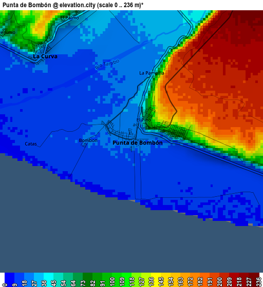
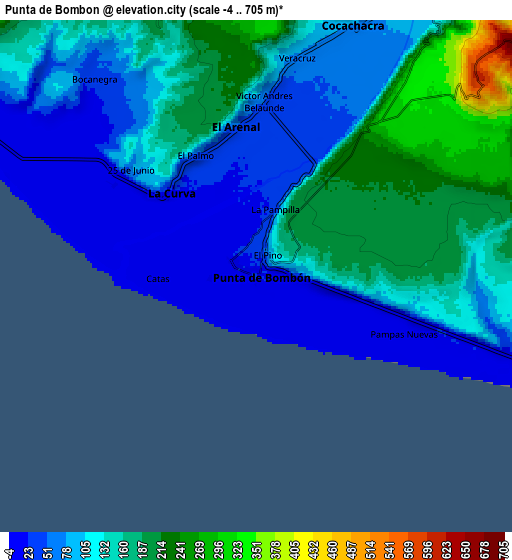
Below is the Elevation map of Punta de Bombón, which displays elevation range with different colors. Scale of the first map is from 0 to 236 m (0 to 774 ft) with average elevation of 67.1 meters (=220 ft) [note 1]
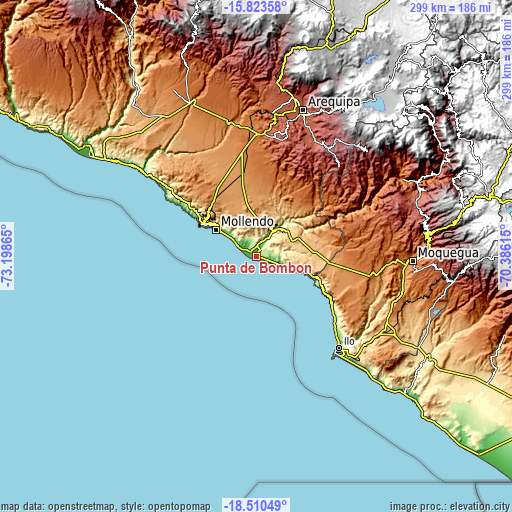
These maps also provides idea of topography and contour of this city, they are displayed at different zoom levels. More info about maps, scale and edge coordinates you can find below images.
| \ | Map #1 | Map #2 | Topo.Map |
| Scale [m] | 0..236 m | -4..705 m | × |
| Scale [ft] | 0..774 ft | -13..2313 ft | × |
| Average | 67.1 m = 220 ft | 119.9 m = 393 ft | × |
| Width | 9.34 km = 5.8 mi | 18.67 km = 11.6 mi | 298.8 km = 185.7 mi |
| Height | 9.34 km = 5.8 mi | 18.67 km = 11.6 mi | 298.8 km = 185.7 mi |
| ↑Max Latitude | -17.129909° | -17.087908° | -15.82358° |
| Latitude at center | -17.1719° | -17.1719° | -17.1719° |
| ↓Min Latitude | -17.213882° | -17.255854° | -18.51049° |
| ← Min Longitude | -71.836345° | -71.880291° | -73.19865° |
| Longitude center | -71.7924° | -71.7924° | -71.7924° |
| →Max Longitude | -71.748455° | -71.704509° | -70.38615° |
Nearby cities:
Cities around Punta de Bombón sort by population:
• Ilo elevation 95 m
70.1 km,  136°
136°
• Mollendo 70 m
28.8 km,  305°
305°
• Cocachacra 82 m
10 km,  21°
21°
• Pacocha 83 m
71 km, 137°
• Tiabaya 2176 m
83.1 km, 15°
• Socabaya 2329 m
83 km, 19°
• La Capilla 1842 m
79.9 km,  54°
54°
• Quequeña 2567 m
77.3 km,  28°
28°
• Yarabamba 2474 m
77.2 km, 25°
• El Algarrobal 125 m
74.9 km,  132°
132°
• Pueblo Nuevo 34 m
68.9 km, 135°
• La Curva 17 m
4.2 km, 312°
Multilingual:
 En español:
Punta de Bombón elevación 25 m.
 En France:
Punta de Bombón élévation 25 m.
 Auf Deutsch:
Punta de Bombón höhe über dem Meeresspiegel ist 25 m.

Sources and notes:
- [note 1] Map square and city borders are not equal. Map elevation data is calculated only from area inside that square.
- [src 1] Elevation data from geonames database provided with same terms of usage.
- [src 2] The elevation map of Punta de Bombón is generated using elevation data from NASA's 3 arcsec (90m) resolution SRTM data.
- [src 3] Base (background) map © OpenStreetMap contributors tiles are generated by Geofabrik and OpenTopoMap.
Copyright & License:
This Punta de Bombón Elevation Map is licensed under CC BY-SA. You may reuse any part from this page, if you give a proper credit by linking to this URL:
 More info on terms of use page.