Tacna elevation
Tacna, Peru elevation is 567 meters and Tacna elevation in feet is 1860 ft above sea level [src 1]. Tacna is a seat of a first-order administrative division (feature code) with elevation that is 1754 meters (5755 ft) smaller than average city elevation in Peru.
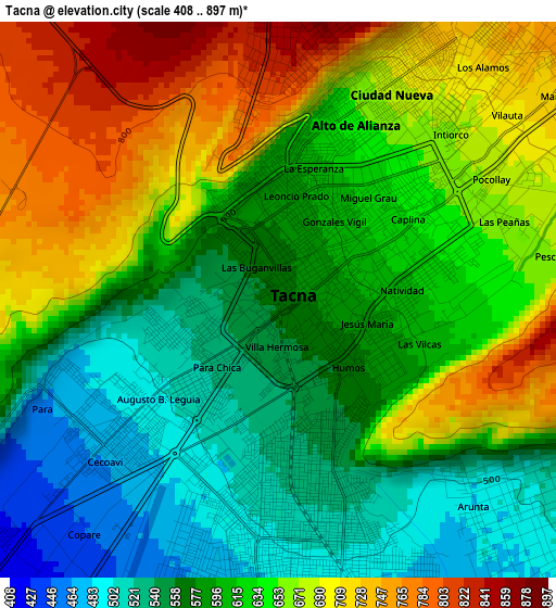
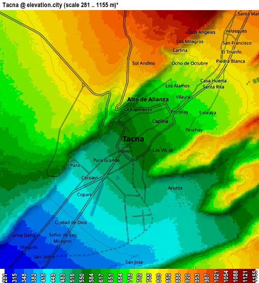
Below is the Elevation map of Tacna, which displays elevation range with different colors. Scale of the first map is from 408 to 897 m (1339 to 2943 ft) with average elevation of 622 meters (=2041 ft) [note 1]
These maps also provides idea of topography and contour of this city, they are displayed at different zoom levels. More info about maps, scale and edge coordinates you can find below images.
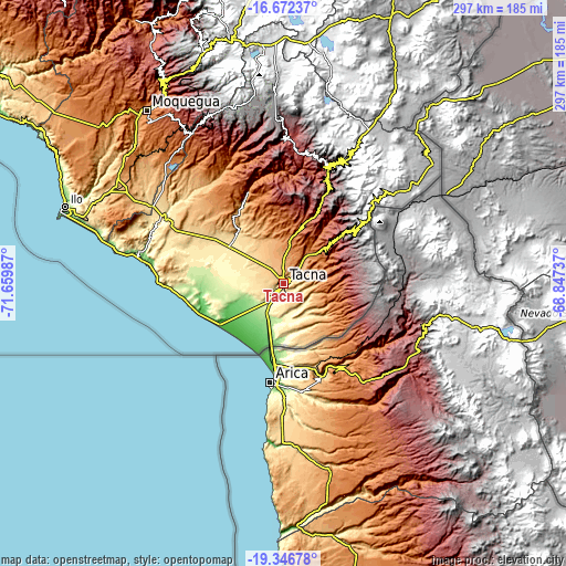
| \ | Map #1 | Map #2 | Topo.Map |
| Scale [m] | 408..897 m | 281..1155 m | × |
| Scale [ft] | 1339..2943 ft | 922..3789 ft | × |
| Average | 622 m = 2041 ft | 664.9 m = 2181 ft | × |
| Width | 9.29 km = 5.8 mi | 18.59 km = 11.6 mi | 297.4 km = 184.8 mi |
| Height | 9.29 km = 5.8 mi | 18.59 km = 11.6 mi | 297.4 km = 184.8 mi |
| ↑Max Latitude | -17.972854° | -17.931048° | -16.67237° |
| Latitude at center | -18.01465° | -18.01465° | -18.01465° |
| ↓Min Latitude | -18.056436° | -18.098212° | -19.34678° |
| ← Min Longitude | -70.297565° | -70.341511° | -71.65987° |
| Longitude center | -70.25362° | -70.25362° | -70.25362° |
| →Max Longitude | -70.209675° | -70.165729° | -68.84737° |
Nearby cities:
Cities around Tacna sort by population:
• Tarata elevation 3083 m
64.5 km,  21°
21°
• Totoral 1979 m
68.7 km,  350°
350°
• Chipispaya 1940 m
57.6 km,  3°
3°
• Calana 896 m
10.8 km,  40°
40°
• Ticaco 3274 m
66.9 km, 19°
• Chucatamani 2344 m
61 km,  13°
13°
• Tarucachi 3112 m
59.5 km, 23°
• Estique 3153 m
58.2 km,  25°
25°
• Palca 2992 m
40.9 km,  49°
49°
• Las Yaras 390 m
36.7 km,  297°
297°
• Sama Grande 520 m
35.5 km,  314°
314°
• Pocollay 701 m
5 km,  59°
59°
Multilingual:
 En español:
Tacna elevación 567 m.
 En France:
Tacna élévation 567 m.


Sources and notes:
- [note 1] Map square and city borders are not equal. Map elevation data is calculated only from area inside that square.
- [src 1] Elevation data from geonames database provided with same terms of usage.
- [src 2] The elevation map of Tacna is generated using elevation data from NASA's 3 arcsec (90m) resolution SRTM data.
- [src 3] Base (background) map © OpenStreetMap contributors tiles are generated by Geofabrik and OpenTopoMap.
Copyright & License:
This Tacna Elevation Map is licensed under CC BY-SA. You may reuse any part from this page, if you give a proper credit by linking to this URL:
 More info on terms of use page.