Chucatamani elevation
Chucatamani (Tacna, Provincia de Tarata), Peru elevation is 2344 meters and Chucatamani elevation in feet is 7690 ft above sea level [src 1]. Chucatamani is a seat of a third-order administrative division (feature code) with elevation that is 23 meters (75 ft) bigger than average city elevation in Peru.
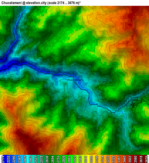
Below is the Elevation map of Chucatamani, which displays elevation range with different colors. Scale of the first map is from 2174 to 3676 m (7133 to 12060 ft) with average elevation of 2856.5 meters (=9372 ft) [note 1]
These maps also provides idea of topography and contour of this city, they are displayed at different zoom levels. More info about maps, scale and edge coordinates you can find below images.
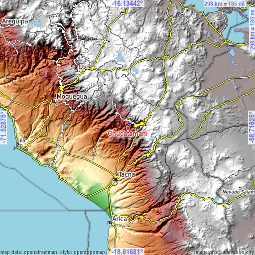
| \ | Map #1 | Topo.Map |
| Scale [m] | 2174..3676 m | × |
| Scale [ft] | 7133..12060 ft | × |
| Average | 2856.5 m = 9372 ft | × |
| Width | 9.32 km = 5.8 mi | 298.3 km = 185.4 mi |
| Height | 9.32 km = 5.8 mi | 298.3 km = 185.4 mi |
| ↑Max Latitude | -17.438639° | -16.13442° |
| Latitude at center | -17.48056° | -17.48056° |
| ↓Min Latitude | -17.522471° | -18.81681° |
| ← Min Longitude | -70.166445° | -71.52875° |
| Longitude center | -70.1225° | -70.1225° |
| →Max Longitude | -70.078555° | -68.71625° |
Nearby cities:
Cities around Chucatamani sort by population:
• Chuquitira elevation 4266 m
22.9 km,  21°
21°
• Candarave 3445 m
27.2 km,  330°
330°
• Quilahuani 3215 m
23.1 km,  321°
321°
• Tarata 3083 m
9.5 km,  85°
85°
• Totoral 1979 m
27 km,  287°
287°
• Chipispaya 1940 m
10.2 km,  259°
259°
• Curibaya 2402 m
25 km,  295°
295°
• Susapaya 3386 m
14.2 km,  355°
355°
• Estique 3153 m
12.9 km,  121°
121°
• Sitajara 3167 m
11.7 km,  354°
354°
• Tarucachi 3112 m
11.1 km, 116°
• Ticaco 3274 m
8.9 km,  64°
64°
Multilingual:
 En español:
Chucatamani elevación 2344 m.
 En France:
Chucatamani élévation 2344 m.
 Auf Deutsch:
Chucatamani höhe über dem Meeresspiegel ist 2344 m.

Sources and notes:
- [note 1] Map square and city borders are not equal. Map elevation data is calculated only from area inside that square.
- [src 1] Elevation data from geonames database provided with same terms of usage.
- [src 2] The elevation map of Chucatamani is generated using elevation data from NASA's 3 arcsec (90m) resolution SRTM data.
- [src 3] Base (background) map © OpenStreetMap contributors tiles are generated by Geofabrik and OpenTopoMap.
Copyright & License:
This Chucatamani Elevation Map is licensed under CC BY-SA. You may reuse any part from this page, if you give a proper credit by linking to this URL:
 More info on terms of use page.