Végueta elevation
Végueta (Lima region, Huaura), Peru elevation is 20 meters and Végueta elevation in feet is 66 ft above sea level [src 1]. Végueta is a populated place (feature code) with elevation that is 2301 meters (7549 ft) smaller than average city elevation in Peru.
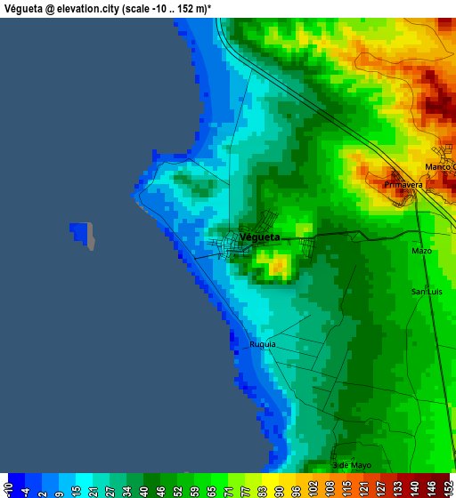
Below is the Elevation map of Végueta, which displays elevation range with different colors. Scale of the first map is from -10 to 152 m (-33 to 499 ft) with average elevation of 49.2 meters (=161 ft) [note 1]
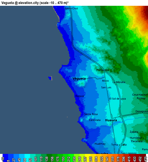
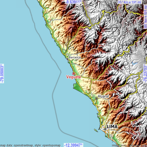
These maps also provides idea of topography and contour of this city, they are displayed at different zoom levels. More info about maps, scale and edge coordinates you can find below images.
| \ | Map #1 | Map #2 | Topo.Map |
| Scale [m] | -10..152 m | -10..470 m | × |
| Scale [ft] | -33..499 ft | -33..1542 ft | × |
| Average | 49.2 m = 161 ft | 98.3 m = 323 ft | × |
| Width | 9.59 km = 6 mi | 19.18 km = 11.9 mi | 306.9 km = 190.7 mi |
| Height | 9.59 km = 6 mi | 19.18 km = 11.9 mi | 307 km = 190.8 mi |
| ↑Max Latitude | -10.979392° | -10.936248° | -9.63911° |
| Latitude at center | -11.02253° | -11.02253° | -11.02253° |
| ↓Min Latitude | -11.065661° | -11.108787° | -12.39947° |
| ← Min Longitude | -77.687725° | -77.731671° | -79.05003° |
| Longitude center | -77.64378° | -77.64378° | -77.64378° |
| →Max Longitude | -77.599835° | -77.555889° | -76.23753° |
Nearby cities:
Cities around Végueta sort by population:
• Huacho elevation 41 m
10.3 km,  155°
155°
• Barranca 52 m
33.1 km,  336°
336°
• Paramonga 11 m
44.7 km,  332°
332°
• Hualmay 39 m
8.8 km, 158°
• Huaura 72 m
7.2 km,  137°
137°
• Supe 54 m
26.1 km, 343°
• Pativilca 76 m
39 km, 336°
• Puerto Supe 25 m
26.9 km, 336°
• Sayán 659 m
50.5 km,  104°
104°
• Caleta de Carquín 13 m
8 km,  166°
166°
• Ambar 2736 m
52.2 km,  52°
52°
• Cruz Blanca 64 m
10 km,  146°
146°
Multilingual:
 En español:
Végueta elevación 20 m.
 En France:
Végueta élévation 20 m.


Sources and notes:
- [note 1] Map square and city borders are not equal. Map elevation data is calculated only from area inside that square.
- [src 1] Elevation data from geonames database provided with same terms of usage.
- [src 2] The elevation map of Végueta is generated using elevation data from NASA's 3 arcsec (90m) resolution SRTM data.
- [src 3] Base (background) map © OpenStreetMap contributors tiles are generated by Geofabrik and OpenTopoMap.
Copyright & License:
This Végueta Elevation Map is licensed under CC BY-SA. You may reuse any part from this page, if you give a proper credit by linking to this URL:
 More info on terms of use page.