Yanahuaya elevation
Yanahuaya (Puno, Provincia de Sandia), Peru elevation is 1907 meters and Yanahuaya elevation in feet is 6257 ft above sea level [src 1]. Yanahuaya is a seat of a third-order administrative division (feature code) with elevation that is 414 meters (1358 ft) smaller than average city elevation in Peru.
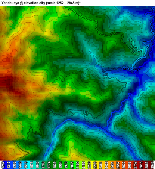
Below is the Elevation map of Yanahuaya, which displays elevation range with different colors. Scale of the first map is from 1252 to 2948 m (4108 to 9672 ft) with average elevation of 1879.3 meters (=6166 ft) [note 1]
These maps also provides idea of topography and contour of this city, they are displayed at different zoom levels. More info about maps, scale and edge coordinates you can find below images.
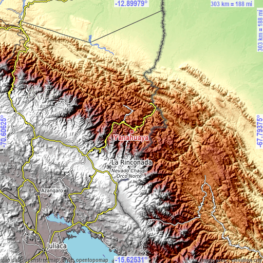
| \ | Map #1 | Topo.Map |
| Scale [m] | 1252..2948 m | × |
| Scale [ft] | 4108..9672 ft | × |
| Average | 1879.3 m = 6166 ft | × |
| Width | 9.47 km = 5.9 mi | 303 km = 188.3 mi |
| Height | 9.47 km = 5.9 mi | 303.1 km = 188.3 mi |
| ↑Max Latitude | -14.224076° | -12.89979° |
| Latitude at center | -14.26667° | -14.26667° |
| ↓Min Latitude | -14.309256° | -15.62531° |
| ← Min Longitude | -69.243945° | -70.60625° |
| Longitude center | -69.2° | -69.2° |
| →Max Longitude | -69.156055° | -67.79375° |
Nearby cities:
Cities around Yanahuaya sort by population:
• La Rinconada elevation 5022 m
48.4 km,  213°
213°
• Crucero 4213 m
86.7 km,  263°
263°
• Cojata 4347 m
85.3 km,  192°
192°
• Usicayos 3780 m
84.1 km,  280°
280°
• Ananea 4690 m
61.2 km,  218°
218°
• Limbani 3341 m
54.3 km, 284°
• Phara 3513 m
51.5 km, 284°
• Patambuco 3594 m
46.3 km, 257°
• Cuyocuyo 3427 m
42.9 km,  237°
237°
• Sina 3472 m
27.5 km,  199°
199°
• Sandia 2907 m
25.4 km, 278°
• Quiaca 2982 m
24.6 km, 221°
Multilingual:
 En español:
Yanahuaya elevación 1907 m.
 En France:
Yanahuaya élévation 1907 m.
 Auf Deutsch:
Yanahuaya höhe über dem Meeresspiegel ist 1907 m.

Sources and notes:
- [note 1] Map square and city borders are not equal. Map elevation data is calculated only from area inside that square.
- [src 1] Elevation data from geonames database provided with same terms of usage.
- [src 2] The elevation map of Yanahuaya is generated using elevation data from NASA's 3 arcsec (90m) resolution SRTM data.
- [src 3] Base (background) map © OpenStreetMap contributors tiles are generated by Geofabrik and OpenTopoMap.
Copyright & License:
This Yanahuaya Elevation Map is licensed under CC BY-SA. You may reuse any part from this page, if you give a proper credit by linking to this URL:
 More info on terms of use page.