Aricapampa elevation
Aricapampa (La Libertad, Sanchez Carrion), Peru elevation is 2598 meters and Aricapampa elevation in feet is 8524 ft above sea level [src 1]. Aricapampa is a seat of a third-order administrative division (feature code) with elevation that is 277 meters (909 ft) bigger than average city elevation in Peru.
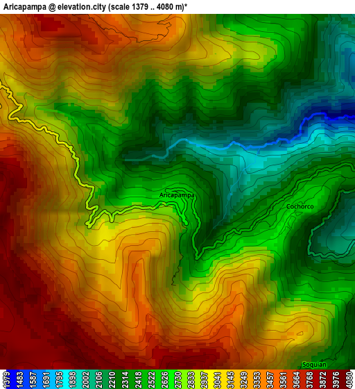
Below is the Elevation map of Aricapampa, which displays elevation range with different colors. Scale of the first map is from 1379 to 4080 m (4524 to 13386 ft) with average elevation of 2878.8 meters (=9445 ft) [note 1]
These maps also provides idea of topography and contour of this city, they are displayed at different zoom levels. More info about maps, scale and edge coordinates you can find below images.
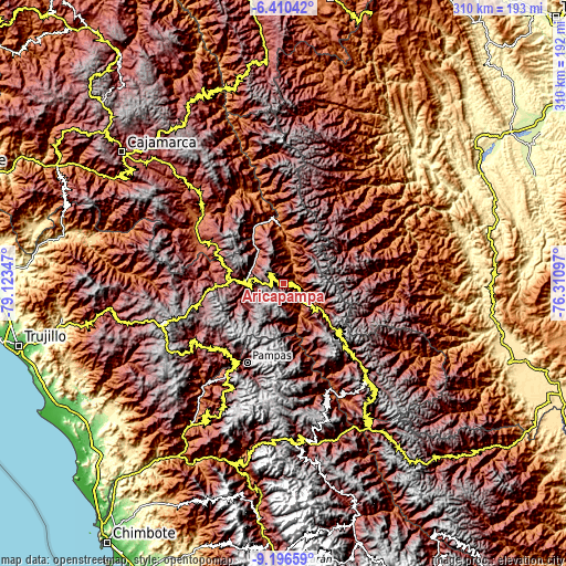
| \ | Map #1 | Topo.Map |
| Scale [m] | 1379..4080 m | × |
| Scale [ft] | 4524..13386 ft | × |
| Average | 2878.8 m = 9445 ft | × |
| Width | 9.68 km = 6 mi | 309.8 km = 192.5 mi |
| Height | 9.68 km = 6 mi | 309.8 km = 192.5 mi |
| ↑Max Latitude | -7.76229° | -6.41042° |
| Latitude at center | -7.80583° | -7.80583° |
| ↓Min Latitude | -7.849366° | -9.19659° |
| ← Min Longitude | -77.761165° | -79.12347° |
| Longitude center | -77.71722° | -77.71722° |
| →Max Longitude | -77.673275° | -76.31097° |
Nearby cities:
Cities around Aricapampa sort by population:
• Huamachuco elevation 3341 m
38.5 km,  270°
270°
• Cajabamba 2636 m
42.3 km,  299°
299°
• Pampas 3162 m
48.2 km,  204°
204°
• Cauday 2682 m
47.3 km, 301°
• Lluchubamba 3215 m
42.2 km,  318°
318°
• Chillia 4114 m
41.6 km,  141°
141°
• Marcabal 2797 m
36.8 km,  288°
288°
• Parcoy 3140 m
36.5 km,  134°
134°
• Curgos 3236 m
25.6 km,  256°
256°
• Sitabamba 3449 m
25.4 km,  184°
184°
• Chugay 3381 m
16.9 km,  279°
279°
• Sartimbamba 2685 m
12.2 km,  346°
346°
Multilingual:
 En español:
Aricapampa elevación 2598 m.
 En France:
Aricapampa élévation 2598 m.
 Auf Deutsch:
Aricapampa höhe über dem Meeresspiegel ist 2598 m.

Sources and notes:
- [note 1] Map square and city borders are not equal. Map elevation data is calculated only from area inside that square.
- [src 1] Elevation data from geonames database provided with same terms of usage.
- [src 2] The elevation map of Aricapampa is generated using elevation data from NASA's 3 arcsec (90m) resolution SRTM data.
- [src 3] Base (background) map © OpenStreetMap contributors tiles are generated by Geofabrik and OpenTopoMap.
Copyright & License:
This Aricapampa Elevation Map is licensed under CC BY-SA. You may reuse any part from this page, if you give a proper credit by linking to this URL:
 More info on terms of use page.