Sitabamba elevation
Sitabamba (La Libertad, Provincia de Santiago de Chuco), Peru elevation is 3449 meters and Sitabamba elevation in feet is 11316 ft above sea level [src 1]. Sitabamba is a seat of a third-order administrative division (feature code) with elevation that is 1128 meters (3701 ft) bigger than average city elevation in Peru.
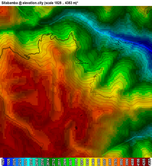
Below is the Elevation map of Sitabamba, which displays elevation range with different colors. Scale of the first map is from 1828 to 4383 m (5997 to 14380 ft) with average elevation of 3376.3 meters (=11077 ft) [note 1]
These maps also provides idea of topography and contour of this city, they are displayed at different zoom levels. More info about maps, scale and edge coordinates you can find below images.
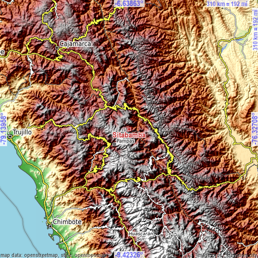
| \ | Map #1 | Topo.Map |
| Scale [m] | 1828..4383 m | × |
| Scale [ft] | 5997..14380 ft | × |
| Average | 3376.3 m = 11077 ft | × |
| Width | 9.68 km = 6 mi | 309.6 km = 192.4 mi |
| Height | 9.68 km = 6 mi | 309.7 km = 192.4 mi |
| ↑Max Latitude | -7.989814° | -6.63863° |
| Latitude at center | -8.03333° | -8.03333° |
| ↓Min Latitude | -8.076842° | -9.42326° |
| ← Min Longitude | -77.777275° | -79.13958° |
| Longitude center | -77.73333° | -77.73333° |
| →Max Longitude | -77.689385° | -76.32708° |
Nearby cities:
Cities around Sitabamba sort by population:
• Pallasca elevation 2589 m
39.4 km,  232°
232°
• Angasmarca 2993 m
38.3 km,  253°
253°
• Sartimbamba 2685 m
37.2 km,  358°
358°
• Lacabamba 3439 m
31.8 km,  215°
215°
• Chugay 3381 m
31.7 km,  332°
332°
• Mollepata 2399 m
30.2 km, 232°
• Curgos 3236 m
30.1 km,  309°
309°
• Conchucos 3244 m
28.9 km,  206°
206°
• Chillia 4114 m
28.5 km,  105°
105°
• Parcoy 3140 m
28 km,  90°
90°
• Pampas 3162 m
26.1 km, 224°
• Aricapampa 2598 m
25.4 km,  4°
4°
Multilingual:
 En español:
Sitabamba elevación 3449 m.
 En France:
Sitabamba élévation 3449 m.
 Auf Deutsch:
Sitabamba höhe über dem Meeresspiegel ist 3449 m.

Sources and notes:
- [note 1] Map square and city borders are not equal. Map elevation data is calculated only from area inside that square.
- [src 1] Elevation data from geonames database provided with same terms of usage.
- [src 2] The elevation map of Sitabamba is generated using elevation data from NASA's 3 arcsec (90m) resolution SRTM data.
- [src 3] Base (background) map © OpenStreetMap contributors tiles are generated by Geofabrik and OpenTopoMap.
Copyright & License:
This Sitabamba Elevation Map is licensed under CC BY-SA. You may reuse any part from this page, if you give a proper credit by linking to this URL:
 More info on terms of use page.