Celendín elevation
Celendín (Cajamarca, Provincia de Celendín), Peru elevation is 2629 meters and Celendín elevation in feet is 8625 ft above sea level [src 1]. Celendín is a populated place (feature code) with elevation that is 308 meters (1010 ft) bigger than average city elevation in Peru.
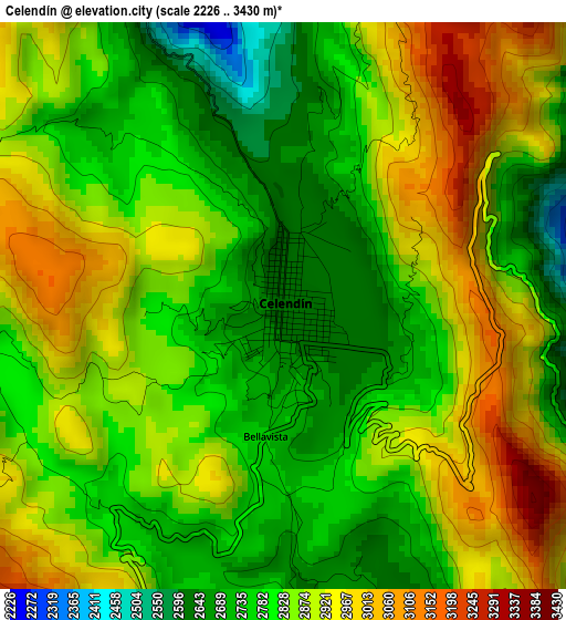
Below is the Elevation map of Celendín, which displays elevation range with different colors. Scale of the first map is from 2226 to 3430 m (7303 to 11253 ft) with average elevation of 2839.8 meters (=9317 ft) [note 1]
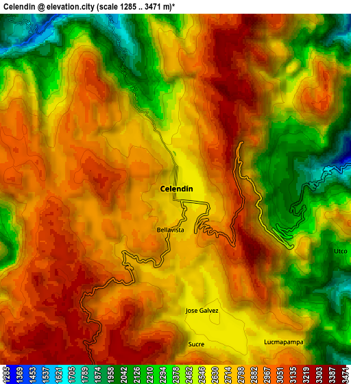
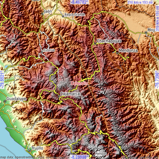
These maps also provides idea of topography and contour of this city, they are displayed at different zoom levels. More info about maps, scale and edge coordinates you can find below images.
| \ | Map #1 | Map #2 | Topo.Map |
| Scale [m] | 2226..3430 m | 1285..3471 m | × |
| Scale [ft] | 7303..11253 ft | 4216..11388 ft | × |
| Average | 2839.8 m = 9317 ft | 2687.4 m = 8817 ft | × |
| Width | 9.7 km = 6 mi | 19.4 km = 12.1 mi | 310.4 km = 192.9 mi |
| Height | 9.7 km = 6 mi | 19.4 km = 12.1 mi | 310.5 km = 192.9 mi |
| ↑Max Latitude | -6.822268° | -6.778632° | -5.46782° |
| Latitude at center | -6.8659° | -6.8659° | -6.8659° |
| ↓Min Latitude | -6.909528° | -6.953152° | -8.25988° |
| ← Min Longitude | -78.189795° | -78.233741° | -79.5521° |
| Longitude center | -78.14585° | -78.14585° | -78.14585° |
| →Max Longitude | -78.101905° | -78.057959° | -76.7396° |
Nearby cities:
Cities around Celendín sort by population:
• Longotea elevation 2708 m
33.7 km,  131°
131°
• Chuquibamba 2825 m
33.3 km,  103°
103°
• Encañada 3297 m
33 km,  222°
222°
• Cocabamba 2740 m
32.8 km,  25°
25°
• Chumuch 2745 m
30.6 km,  345°
345°
• Oxamarca 2665 m
20.6 km,  154°
154°
• Balsas 840 m
14.7 km,  75°
75°
• Sorochuco 2657 m
13 km,  247°
247°
• Utco 1622 m
12 km,  118°
118°
• Lucmapampa 2797 m
10.6 km, 151°
• Huacapampa 2591 m
7.6 km,  169°
169°
• Sucre 2865 m
7.5 km,  183°
183°
Multilingual:
 En español:
Celendín elevación 2629 m.
 En France:
Celendín élévation 2629 m.
 Auf Deutsch:
Celendín höhe über dem Meeresspiegel ist 2629 m.

Sources and notes:
- [note 1] Map square and city borders are not equal. Map elevation data is calculated only from area inside that square.
- [src 1] Elevation data from geonames database provided with same terms of usage.
- [src 2] The elevation map of Celendín is generated using elevation data from NASA's 3 arcsec (90m) resolution SRTM data.
- [src 3] Base (background) map © OpenStreetMap contributors tiles are generated by Geofabrik and OpenTopoMap.
Copyright & License:
This Celendín Elevation Map is licensed under CC BY-SA. You may reuse any part from this page, if you give a proper credit by linking to this URL:
 More info on terms of use page.