Cocabamba elevation
Cocabamba (Amazonas, Provincia de Luya), Peru elevation is 2740 meters and Cocabamba elevation in feet is 8990 ft above sea level [src 1]. Cocabamba is a seat of a third-order administrative division (feature code) with elevation that is 419 meters (1375 ft) bigger than average city elevation in Peru.
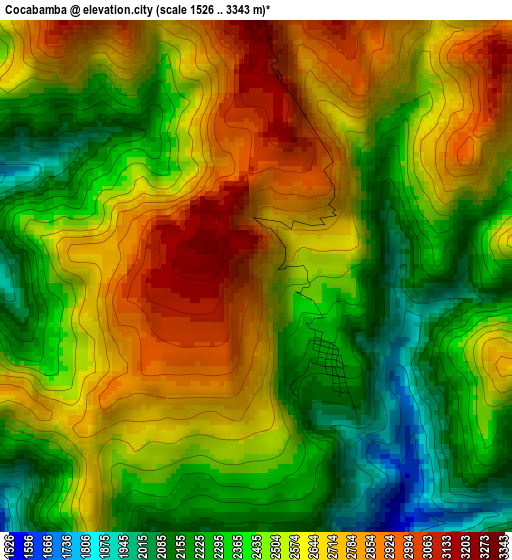
Below is the Elevation map of Cocabamba, which displays elevation range with different colors. Scale of the first map is from 1526 to 3343 m (5007 to 10968 ft) with average elevation of 2506.1 meters (=8222 ft) [note 1]
These maps also provides idea of topography and contour of this city, they are displayed at different zoom levels. More info about maps, scale and edge coordinates you can find below images.
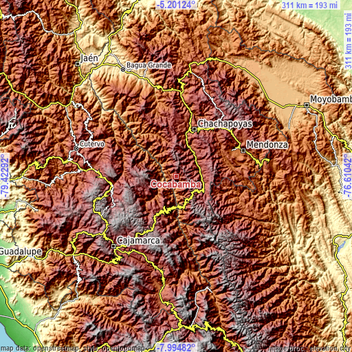
| \ | Map #1 | Topo.Map |
| Scale [m] | 1526..3343 m | × |
| Scale [ft] | 5007..10968 ft | × |
| Average | 2506.1 m = 8222 ft | × |
| Width | 9.71 km = 6 mi | 310.6 km = 193 mi |
| Height | 9.71 km = 6 mi | 310.6 km = 193 mi |
| ↑Max Latitude | -6.556344° | -5.20124° |
| Latitude at center | -6.6° | -6.6° |
| ↓Min Latitude | -6.643652° | -7.99482° |
| ← Min Longitude | -78.060615° | -79.42292° |
| Longitude center | -78.01667° | -78.01667° |
| →Max Longitude | -77.972725° | -76.61042° |
Nearby cities:
Cities around Cocabamba sort by population:
• Celendín elevation 2629 m
32.8 km,  205°
205°
• Levanto 2656 m
35 km,  21°
21°
• Colcamar 2323 m
33.6 km,  8°
8°
• Maino 2341 m
32.9 km,  27°
27°
• Magdalena 1910 m
28.3 km, 27°
• Tingo 1946 m
27.9 km, 24°
• Balsas 840 m
25.9 km,  180°
180°
• La Jalca 2850 m
25.6 km,  60°
60°
• Montevideo 2444 m
23.7 km,  94°
94°
• Duraznopampa 2212 m
23.1 km, 88°
• Chumuch 2745 m
22.1 km,  270°
270°
• Longuita 2794 m
21.3 km, 14°
Multilingual:
 En español:
Cocabamba elevación 2740 m.
 En France:
Cocabamba élévation 2740 m.
 Auf Deutsch:
Cocabamba höhe über dem Meeresspiegel ist 2740 m.

Sources and notes:
- [note 1] Map square and city borders are not equal. Map elevation data is calculated only from area inside that square.
- [src 1] Elevation data from geonames database provided with same terms of usage.
- [src 2] The elevation map of Cocabamba is generated using elevation data from NASA's 3 arcsec (90m) resolution SRTM data.
- [src 3] Base (background) map © OpenStreetMap contributors tiles are generated by Geofabrik and OpenTopoMap.
Copyright & License:
This Cocabamba Elevation Map is licensed under CC BY-SA. You may reuse any part from this page, if you give a proper credit by linking to this URL:
 More info on terms of use page.