Huari elevation
Huari (Ancash, Provincia de Huari), Peru elevation is 3815 meters and Huari elevation in feet is 12516 ft above sea level [src 1]. Huari is a seat of a third-order administrative division (feature code) with elevation that is 1494 meters (4902 ft) bigger than average city elevation in Peru.
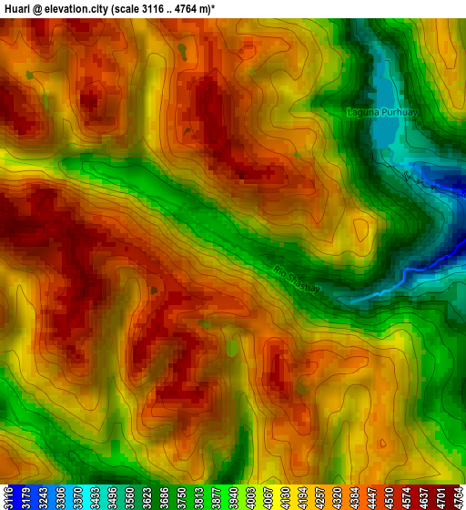
Below is the Elevation map of Huari, which displays elevation range with different colors. Scale of the first map is from 3116 to 4764 m (10223 to 15630 ft) with average elevation of 4141.4 meters (=13587 ft) [note 1]
These maps also provides idea of topography and contour of this city, they are displayed at different zoom levels. More info about maps, scale and edge coordinates you can find below images.
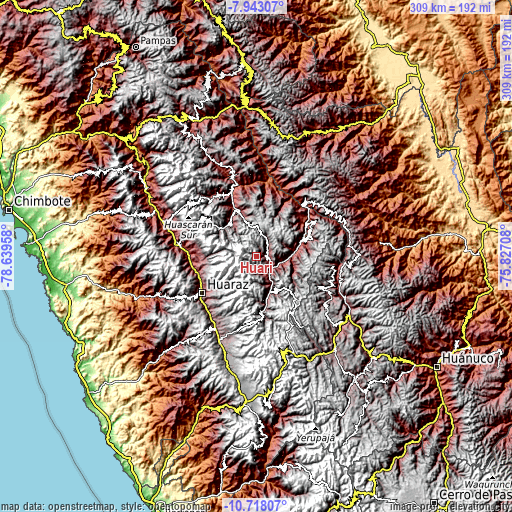
| \ | Map #1 | Topo.Map |
| Scale [m] | 3116..4764 m | × |
| Scale [ft] | 10223..15630 ft | × |
| Average | 4141.4 m = 13587 ft | × |
| Width | 9.64 km = 6 mi | 308.6 km = 191.8 mi |
| Height | 9.64 km = 6 mi | 308.6 km = 191.8 mi |
| ↑Max Latitude | -9.289964° | -7.94307° |
| Latitude at center | -9.33333° | -9.33333° |
| ↓Min Latitude | -9.376691° | -10.71807° |
| ← Min Longitude | -77.277275° | -78.63958° |
| Longitude center | -77.23333° | -77.23333° |
| →Max Longitude | -77.189385° | -75.82708° |
Nearby cities:
Cities around Huari sort by population:
• Jangas elevation 2817 m
38.4 km,  258°
258°
• Tarica 2822 m
38 km, 259°
• Uco 3350 m
37.2 km,  64°
64°
• Aco 2990 m
36.4 km, 263°
• Anra 3290 m
35.8 km,  71°
71°
• Chingas 2852 m
35.6 km,  48°
48°
• Aczo 2668 m
33.5 km, 53°
• Huacachi 3517 m
32.3 km,  86°
86°
• San Luis 3065 m
30.6 km,  335°
335°
• San Marcos 2969 m
22.9 km,  158°
158°
• Chacas 3900 m
19.9 km,  304°
304°
• Huachis 3539 m
15.8 km,  125°
125°
Multilingual:
 En español:
Huari elevación 3815 m.
 En France:
Huari élévation 3815 m.


Sources and notes:
- [note 1] Map square and city borders are not equal. Map elevation data is calculated only from area inside that square.
- [src 1] Elevation data from geonames database provided with same terms of usage.
- [src 2] The elevation map of Huari is generated using elevation data from NASA's 3 arcsec (90m) resolution SRTM data.
- [src 3] Base (background) map © OpenStreetMap contributors tiles are generated by Geofabrik and OpenTopoMap.
Copyright & License:
This Huari Elevation Map is licensed under CC BY-SA. You may reuse any part from this page, if you give a proper credit by linking to this URL:
 More info on terms of use page.