Iquitos elevation
Iquitos (Loreto, Provincia de Maynas), Peru elevation is 92 meters and Iquitos elevation in feet is 302 ft above sea level [src 1]. Iquitos is a seat of a first-order administrative division (feature code) with elevation that is 2229 meters (7313 ft) smaller than average city elevation in Peru.
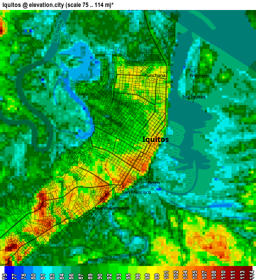
Below is the Elevation map of Iquitos, which displays elevation range with different colors. Scale of the first map is from 75 to 114 m (246 to 374 ft) with average elevation of 88.7 meters (=291 ft) [note 1]
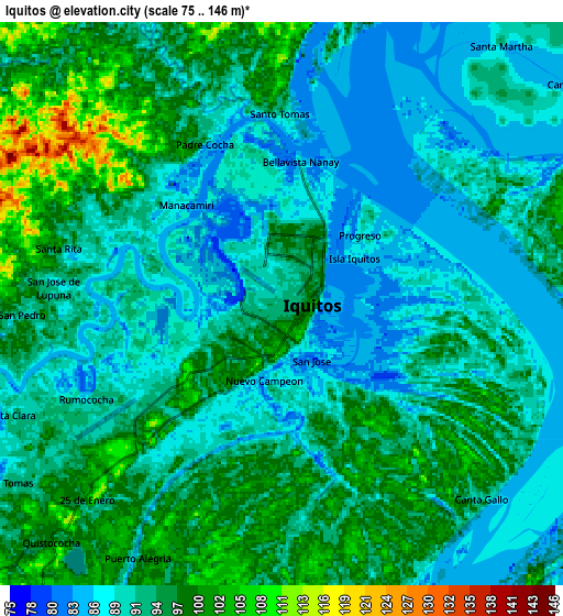
These maps also provides idea of topography and contour of this city, they are displayed at different zoom levels. More info about maps, scale and edge coordinates you can find below images.
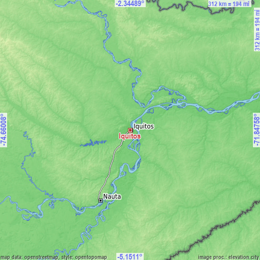
| \ | Map #1 | Map #2 | Topo.Map |
| Scale [m] | 75..114 m | 75..146 m | × |
| Scale [ft] | 246..374 ft | 246..479 ft | × |
| Average | 88.7 m = 291 ft | 93.1 m = 305 ft | × |
| Width | 9.75 km = 6.1 mi | 19.5 km = 12.1 mi | 312 km = 193.9 mi |
| Height | 9.75 km = 6.1 mi | 19.5 km = 12.1 mi | 312.1 km = 193.9 mi |
| ↑Max Latitude | -3.705268° | -3.661413° | -2.34489° |
| Latitude at center | -3.74912° | -3.74912° | -3.74912° |
| ↓Min Latitude | -3.79297° | -3.836818° | -5.1511° |
| ← Min Longitude | -73.297775° | -73.341721° | -74.66008° |
| Longitude center | -73.25383° | -73.25383° | -73.25383° |
| →Max Longitude | -73.209885° | -73.165939° | -71.84758° |
Nearby cities:
Cities around Iquitos sort by population:
• San Antonio del Estrecho elevation 116 m
158.4 km,  24°
24°
• Saquena 105 m
106.1 km,  195°
195°
• Bretaña 109 m
203.7 km,  214°
214°
• Trompeteros 128 m
200.3 km,  267°
267°
• Concordia 118 m
192.4 km,  241°
241°
• Pebas 73 m
162.1 km,  73°
73°
• Requena 108 m
160.1 km, 204°
• Parinari 118 m
159.3 km, 235°
• Genaro Herrera 112 m
136.7 km, 199°
• Nauta 91 m
93.2 km, 200°
• San Juan 99 m
37.9 km,  246°
246°
• Indiana 94 m
35.7 km,  39°
39°
Multilingual:
 En español:
Iquitos elevación 92 m.
 En France:
Iquitos élévation 92 m.


Sources and notes:
- [note 1] Map square and city borders are not equal. Map elevation data is calculated only from area inside that square.
- [src 1] Elevation data from geonames database provided with same terms of usage.
- [src 2] The elevation map of Iquitos is generated using elevation data from NASA's 3 arcsec (90m) resolution SRTM data.
- [src 3] Base (background) map © OpenStreetMap contributors tiles are generated by Geofabrik and OpenTopoMap.
Copyright & License:
This Iquitos Elevation Map is licensed under CC BY-SA. You may reuse any part from this page, if you give a proper credit by linking to this URL:
 More info on terms of use page.