Saquena elevation
Saquena (Loreto, Provincia de Requena), Peru elevation is 105 meters and Saquena elevation in feet is 344 ft above sea level [src 1]. Saquena is a populated place (feature code) with elevation that is 2216 meters (7270 ft) smaller than average city elevation in Peru.
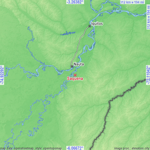
Below is the Elevation map of Saquena, which displays elevation range with different colors. Scale of the first map is from 88 to 118 m (289 to 387 ft) with average elevation of 103.3 meters (=339 ft) [note 1]
These maps also provides idea of topography and contour of this city, they are displayed at different zoom levels. More info about maps, scale and edge coordinates you can find below images.


| \ | Map #1 | Map #2 | Topo.Map |
| Scale [m] | 88..118 m | 83..127 m | × |
| Scale [ft] | 289..387 ft | 272..417 ft | × |
| Average | 103.3 m = 339 ft | 105 m = 344 ft | × |
| Width | 9.74 km = 6.1 mi | 19.48 km = 12.1 mi | 311.7 km = 193.7 mi |
| Height | 9.74 km = 6.1 mi | 19.48 km = 12.1 mi | 311.7 km = 193.7 mi |
| ↑Max Latitude | -4.622869° | -4.579065° | -3.26382° |
| Latitude at center | -4.66667° | -4.66667° | -4.66667° |
| ↓Min Latitude | -4.710468° | -4.754264° | -6.06672° |
| ← Min Longitude | -73.560615° | -73.604561° | -74.92292° |
| Longitude center | -73.51667° | -73.51667° | -73.51667° |
| →Max Longitude | -73.472725° | -73.428779° | -72.11042° |
Nearby cities:
Cities around Saquena sort by population:
• Iquitos elevation 92 m
106.1 km,  15°
15°
• Santa Elena 124 m
164.4 km,  202°
202°
• Tamanco 122 m
158.6 km,  213°
213°
• Concordia 118 m
140.8 km,  274°
274°
• Indiana 94 m
139.6 km, 21°
• Iberia 116 m
131.5 km, 212°
• Bretaña 109 m
108 km,  231°
231°
• Parinari 118 m
102.2 km,  276°
276°
• San Juan 99 m
87.1 km,  356°
356°
• Requena 108 m
57.3 km,  220°
220°
• Genaro Herrera 112 m
31.6 km, 212°
• Nauta 91 m
15.3 km,  346°
346°
Multilingual:
 En español:
Saquena elevación 105 m.
 En France:
Saquena élévation 105 m.


Sources and notes:
- [note 1] Map square and city borders are not equal. Map elevation data is calculated only from area inside that square.
- [src 1] Elevation data from geonames database provided with same terms of usage.
- [src 2] The elevation map of Saquena is generated using elevation data from NASA's 3 arcsec (90m) resolution SRTM data.
- [src 3] Base (background) map © OpenStreetMap contributors tiles are generated by Geofabrik and OpenTopoMap.
Copyright & License:
This Saquena Elevation Map is licensed under CC BY-SA. You may reuse any part from this page, if you give a proper credit by linking to this URL:
 More info on terms of use page.