Bejuco elevation
Bejuco (Panamá Oeste), Panama elevation is 29 meters and Bejuco elevation in feet is 95 ft above sea level [src 1]. Bejuco is a seat of a third-order administrative division (feature code) with elevation that is 143 meters (469 ft) smaller than average city elevation in Panama.
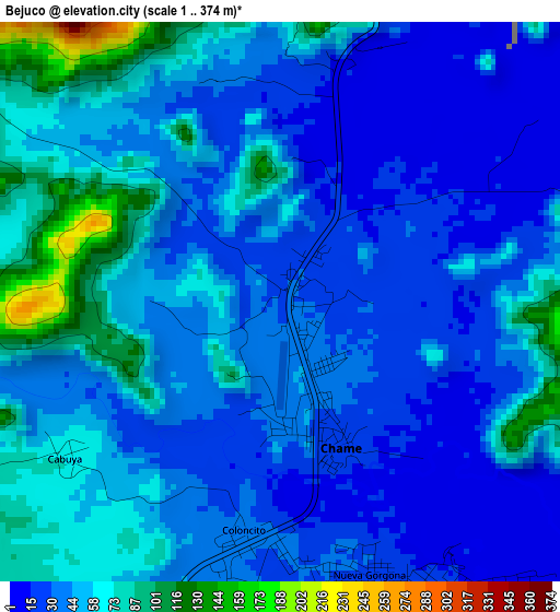
Below is the Elevation map of Bejuco, which displays elevation range with different colors. Scale of the first map is from 1 to 374 m (3 to 1227 ft) with average elevation of 46.4 meters (=152 ft) [note 1]
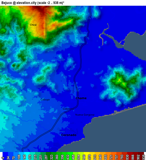
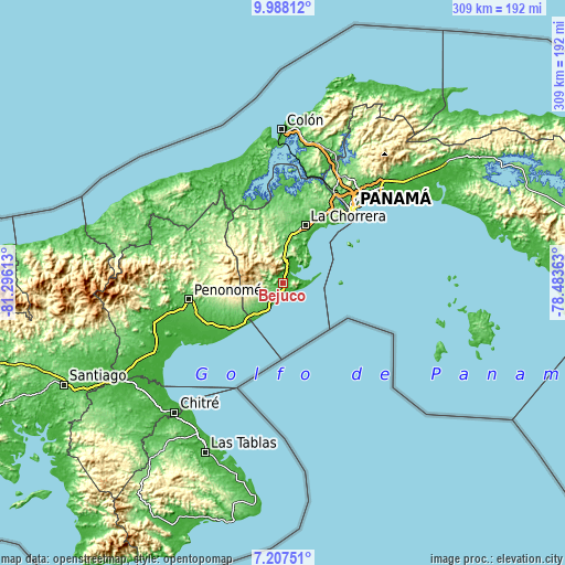
These maps also provides idea of topography and contour of this city, they are displayed at different zoom levels. More info about maps, scale and edge coordinates you can find below images.
| \ | Map #1 | Map #2 | Topo.Map |
| Scale [m] | 1..374 m | -2..938 m | × |
| Scale [ft] | 3..1227 ft | -7..3077 ft | × |
| Average | 46.4 m = 152 ft | 123.5 m = 405 ft | × |
| Width | 9.66 km = 6 mi | 19.33 km = 12 mi | 309.2 km = 192.1 mi |
| Height | 9.66 km = 6 mi | 19.33 km = 12 mi | 309.2 km = 192.1 mi |
| ↑Max Latitude | 8.643819° | 8.687262° | 9.98812° |
| Latitude at center | 8.60037° | 8.60037° | 8.60037° |
| ↓Min Latitude | 8.556916° | 8.513458° | 7.20751° |
| ← Min Longitude | -79.933825° | -79.977771° | -81.29613° |
| Longitude center | -79.88988° | -79.88988° | -79.88988° |
| →Max Longitude | -79.845935° | -79.801989° | -78.48363° |
Nearby cities:
Cities around Bejuco sort by population:
• Nueva Gorgona elevation 21 m
5.8 km,  164°
164°
• Las Lajas 74 m
7.5 km,  221°
221°
• Chame 39 m
2.6 km,  170°
170°
• San José 63 m
8.8 km,  210°
210°
• El Espavé 18 m
7 km,  12°
12°
• Cermeño 207 m
16.1 km, 14°
• San Carlos 23 m
16.2 km, 208°
• Cabuya 76 m
5 km,  235°
235°
• Sorá 525 m
13.5 km,  285°
285°
• Buenos Aires 232 m
7.2 km,  298°
298°
• El Líbano 41 m
6.3 km,  73°
73°
• Guayabito 255 m
14.8 km,  246°
246°
Multilingual:
 En español:
Bejuco elevación 29 m.
 En France:
Bejuco élévation 29 m.


Sources and notes:
- [note 1] Map square and city borders are not equal. Map elevation data is calculated only from area inside that square.
- [src 1] Elevation data from geonames database provided with same terms of usage.
- [src 2] The elevation map of Bejuco is generated using elevation data from NASA's 3 arcsec (90m) resolution SRTM data.
- [src 3] Base (background) map © OpenStreetMap contributors tiles are generated by Geofabrik and OpenTopoMap.
Copyright & License:
This Bejuco Elevation Map is licensed under CC BY-SA. You may reuse any part from this page, if you give a proper credit by linking to this URL:
 More info on terms of use page.