San Carlos elevation
San Carlos (Panamá Oeste), Panama elevation is 23 meters and San Carlos elevation in feet is 75 ft above sea level [src 1]. San Carlos is a seat of a second-order administrative division (feature code) with elevation that is 149 meters (489 ft) smaller than average city elevation in Panama.
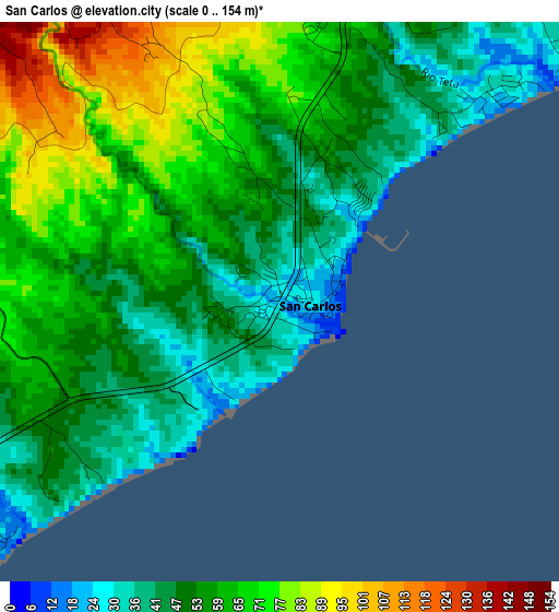
Below is the Elevation map of San Carlos, which displays elevation range with different colors. Scale of the first map is from 0 to 154 m (0 to 505 ft) with average elevation of 57.5 meters (=189 ft) [note 1]
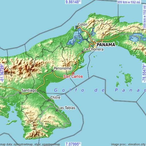
These maps also provides idea of topography and contour of this city, they are displayed at different zoom levels. More info about maps, scale and edge coordinates you can find below images.
| \ | Map #1 | Topo.Map |
| Scale [m] | 0..154 m | × |
| Scale [ft] | 0..505 ft | × |
| Average | 57.5 m = 189 ft | × |
| Width | 9.67 km = 6 mi | 309.3 km = 192.2 mi |
| Height | 9.67 km = 6 mi | 309.3 km = 192.2 mi |
| ↑Max Latitude | 8.516693° | 9.86148° |
| Latitude at center | 8.47323° | 8.47323° |
| ↓Min Latitude | 8.429762° | 7.07995° |
| ← Min Longitude | -80.004985° | -81.36729° |
| Longitude center | -79.96104° | -79.96104° |
| →Max Longitude | -79.917095° | -78.55479° |
Nearby cities:
Cities around San Carlos sort by population:
• Bejuco elevation 29 m
16.2 km,  28°
28°
• Nueva Gorgona 21 m
12.7 km,  47°
47°
• Las Lajas 74 m
9 km,  18°
18°
• Chame 39 m
14.2 km,  35°
35°
• Las Colinas 363 m
15.9 km,  302°
302°
• San José 63 m
7.4 km, 26°
• Cabuya 76 m
11.9 km, 18°
• El Higo 68 m
8.7 km,  250°
250°
• Las Uvas 61 m
4.6 km, 250°
• La Ermita 99 m
12 km,  260°
260°
• Guayabito 255 m
10.1 km,  325°
325°
• El Espino 77 m
5.7 km,  274°
274°
Multilingual:
 En español:
San Carlos elevación 23 m.
 En France:
San Carlos élévation 23 m.
 Auf Deutsch:
San Carlos höhe über dem Meeresspiegel ist 23 m.

Sources and notes:
- [note 1] Map square and city borders are not equal. Map elevation data is calculated only from area inside that square.
- [src 1] Elevation data from geonames database provided with same terms of usage.
- [src 2] The elevation map of San Carlos is generated using elevation data from NASA's 3 arcsec (90m) resolution SRTM data.
- [src 3] Base (background) map © OpenStreetMap contributors tiles are generated by Geofabrik and OpenTopoMap.
Copyright & License:
This San Carlos Elevation Map is licensed under CC BY-SA. You may reuse any part from this page, if you give a proper credit by linking to this URL:
 More info on terms of use page.