Las Colinas elevation
Las Colinas (Panamá Oeste), Panama elevation is 363 meters and Las Colinas elevation in feet is 1191 ft above sea level [src 1]. Las Colinas is a populated place (feature code) with elevation that is 191 meters (627 ft) bigger than average city elevation in Panama.
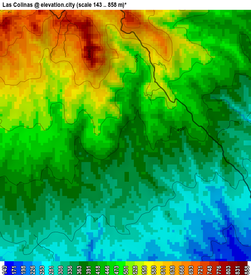
Below is the Elevation map of Las Colinas, which displays elevation range with different colors. Scale of the first map is from 143 to 858 m (469 to 2815 ft) with average elevation of 426.3 meters (=1399 ft) [note 1]
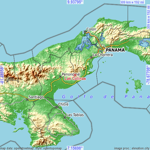
These maps also provides idea of topography and contour of this city, they are displayed at different zoom levels. More info about maps, scale and edge coordinates you can find below images.
| \ | Map #1 | Topo.Map |
| Scale [m] | 143..858 m | × |
| Scale [ft] | 469..2815 ft | × |
| Average | 426.3 m = 1399 ft | × |
| Width | 9.66 km = 6 mi | 309.2 km = 192.1 mi |
| Height | 9.66 km = 6 mi | 309.2 km = 192.1 mi |
| ↑Max Latitude | 8.593454° | 9.93795° |
| Latitude at center | 8.55° | 8.55° |
| ↓Min Latitude | 8.506541° | 7.15698° |
| ← Min Longitude | -80.127275° | -81.48958° |
| Longitude center | -80.08333° | -80.08333° |
| →Max Longitude | -80.039385° | -78.67708° |
Nearby cities:
Cities around Las Colinas sort by population:
• Alto de La Estancia elevation 517 m
11.9 km,  290°
290°
• Sorá 525 m
12.2 km,  41°
41°
• El Higo 68 m
12.5 km,  155°
155°
• El Retiro 163 m
11 km,  225°
225°
• La Ermita 99 m
10.6 km,  171°
171°
• La Laguna 608 m
7.2 km,  33°
33°
• Los Llanitos 692 m
5.5 km,  346°
346°
• Caballero 304 m
12.6 km,  266°
266°
• Cabuya 391 m
9.3 km, 267°
• Guayabito 255 m
7.7 km,  91°
91°
• Santa Rita 176 m
12.7 km,  239°
239°
• El Espino 77 m
11.2 km,  136°
136°
Multilingual:
 En español:
Las Colinas elevación 363 m.
 En France:
Las Colinas élévation 363 m.
 Auf Deutsch:
Las Colinas höhe über dem Meeresspiegel ist 363 m.

Sources and notes:
- [note 1] Map square and city borders are not equal. Map elevation data is calculated only from area inside that square.
- [src 1] Elevation data from geonames database provided with same terms of usage.
- [src 2] The elevation map of Las Colinas is generated using elevation data from NASA's 3 arcsec (90m) resolution SRTM data.
- [src 3] Base (background) map © OpenStreetMap contributors tiles are generated by Geofabrik and OpenTopoMap.
Copyright & License:
This Las Colinas Elevation Map is licensed under CC BY-SA. You may reuse any part from this page, if you give a proper credit by linking to this URL:
 More info on terms of use page.