Sorá elevation
Sorá (Panamá Oeste), Panama elevation is 525 meters and Sorá elevation in feet is 1722 ft above sea level [src 1]. Sorá is a seat of a third-order administrative division (feature code) with elevation that is 353 meters (1158 ft) bigger than average city elevation in Panama.
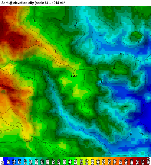
Below is the Elevation map of Sorá, which displays elevation range with different colors. Scale of the first map is from 64 to 1014 m (210 to 3327 ft) with average elevation of 407.8 meters (=1338 ft) [note 1]
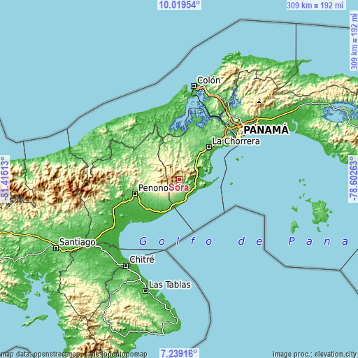
These maps also provides idea of topography and contour of this city, they are displayed at different zoom levels. More info about maps, scale and edge coordinates you can find below images.
| \ | Map #1 | Topo.Map |
| Scale [m] | 64..1014 m | × |
| Scale [ft] | 210..3327 ft | × |
| Average | 407.8 m = 1338 ft | × |
| Width | 9.66 km = 6 mi | 309.1 km = 192.1 mi |
| Height | 9.66 km = 6 mi | 309.2 km = 192.1 mi |
| ↑Max Latitude | 8.675355° | 10.01954° |
| Latitude at center | 8.63191° | 8.63191° |
| ↓Min Latitude | 8.58846° | 7.23916° |
| ← Min Longitude | -80.052825° | -81.41513° |
| Longitude center | -80.00888° | -80.00888° |
| →Max Longitude | -79.964935° | -78.60263° |
Nearby cities:
Cities around Sorá sort by population:
• Bejuco elevation 29 m
13.5 km,  105°
105°
• Las Lajas 74 m
12.2 km,  138°
138°
• Chame 39 m
14.8 km, 114°
• Las Colinas 363 m
12.2 km,  221°
221°
• San José 63 m
14 km, 142°
• El Espavé 18 m
15 km,  77°
77°
• Cabuya 76 m
11 km,  125°
125°
• El Cacao 204 m
14.4 km,  358°
358°
• Buenos Aires 232 m
6.7 km,  90°
90°
• La Laguna 608 m
5.2 km,  233°
233°
• Los Llanitos 692 m
10.2 km,  248°
248°
• Guayabito 255 m
9.3 km,  183°
183°
Multilingual:
 En español:
Sorá elevación 525 m.
 En France:
Sorá élévation 525 m.


Sources and notes:
- [note 1] Map square and city borders are not equal. Map elevation data is calculated only from area inside that square.
- [src 1] Elevation data from geonames database provided with same terms of usage.
- [src 2] The elevation map of Sorá is generated using elevation data from NASA's 3 arcsec (90m) resolution SRTM data.
- [src 3] Base (background) map © OpenStreetMap contributors tiles are generated by Geofabrik and OpenTopoMap.
Copyright & License:
This Sorá Elevation Map is licensed under CC BY-SA. You may reuse any part from this page, if you give a proper credit by linking to this URL:
 More info on terms of use page.