Kankintú elevation
Kankintú (Ngöbe-Buglé), Panama elevation is 85 meters and Kankintú elevation in feet is 279 ft above sea level [src 1]. Kankintú is a seat of a third-order administrative division (feature code) with elevation that is 87 meters (285 ft) smaller than average city elevation in Panama.
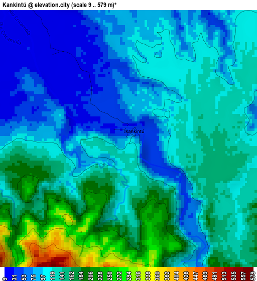
Below is the Elevation map of Kankintú, which displays elevation range with different colors. Scale of the first map is from 9 to 579 m (30 to 1900 ft) with average elevation of 124 meters (=407 ft) [note 1]
These maps also provides idea of topography and contour of this city, they are displayed at different zoom levels. More info about maps, scale and edge coordinates you can find below images.
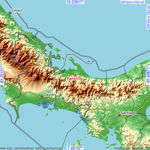
| \ | Map #1 | Topo.Map |
| Scale [m] | 9..579 m | × |
| Scale [ft] | 30..1900 ft | × |
| Average | 124 m = 407 ft | × |
| Width | 9.66 km = 6 mi | 309 km = 192 mi |
| Height | 9.66 km = 6 mi | 309 km = 192 mi |
| ↑Max Latitude | 8.88681° | 10.23017° |
| Latitude at center | 8.84339° | 8.84339° |
| ↓Min Latitude | 8.799965° | 7.45137° |
| ← Min Longitude | -81.858905° | -83.22121° |
| Longitude center | -81.81496° | -81.81496° |
| →Max Longitude | -81.771015° | -80.40871° |
Nearby cities:
Cities around Kankintú sort by population:
• Chiriquí Grande elevation 35 m
35.1 km,  288°
288°
• Kusapín 48 m
38 km,  348°
348°
• Bisira 16 m
7.2 km,  323°
323°
• Tobobe 11 m
30.9 km,  358°
358°
• Bahía Azul 13 m
34.3 km, 345°
• Quebrada Tula 33 m
19.9 km,  269°
269°
• Rámbala 32 m
41.1 km,  282°
282°
• Cascabel 1188 m
35.8 km,  190°
190°
• Mirones 996 m
33.3 km,  162°
162°
• Piedra Roja 788 m
31.3 km,  166°
166°
• Boca del Río Chiriquí -1 m
26.6 km,  89°
89°
• Cuoronte 396 m
19 km, 170°
Multilingual:
 En español:
Kankintú elevación 85 m.
 En France:
Kankintú élévation 85 m.


Sources and notes:
- [note 1] Map square and city borders are not equal. Map elevation data is calculated only from area inside that square.
- [src 1] Elevation data from geonames database provided with same terms of usage.
- [src 2] The elevation map of Kankintú is generated using elevation data from NASA's 3 arcsec (90m) resolution SRTM data.
- [src 3] Base (background) map © OpenStreetMap contributors tiles are generated by Geofabrik and OpenTopoMap.
Copyright & License:
This Kankintú Elevation Map is licensed under CC BY-SA. You may reuse any part from this page, if you give a proper credit by linking to this URL:
 More info on terms of use page.