Rámbala elevation
Rámbala (Bocas del Toro), Panama elevation is 32 meters and Rámbala elevation in feet is 105 ft above sea level [src 1]. Rámbala is a seat of a third-order administrative division (feature code) with elevation that is 140 meters (459 ft) smaller than average city elevation in Panama.
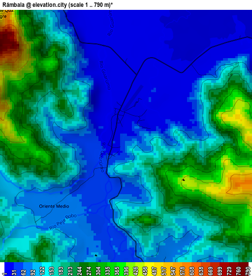
Below is the Elevation map of Rámbala, which displays elevation range with different colors. Scale of the first map is from 1 to 790 m (3 to 2592 ft) with average elevation of 153.2 meters (=503 ft) [note 1]
These maps also provides idea of topography and contour of this city, they are displayed at different zoom levels. More info about maps, scale and edge coordinates you can find below images.
| \ | Map #1 | Topo.Map |
| Scale [m] | 1..790 m | × |
| Scale [ft] | 3..2592 ft | × |
| Average | 153.2 m = 503 ft | × |
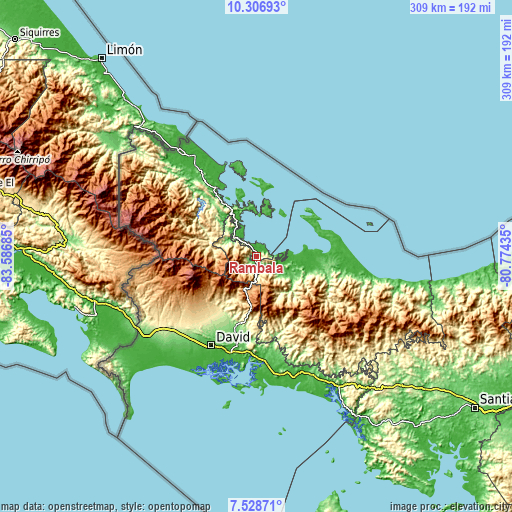
| Width | 9.65 km = 6 mi | 308.9 km = 191.9 mi |
| Height | 9.65 km = 6 mi | 308.9 km = 191.9 mi |
| ↑Max Latitude | 8.963871° | 10.30693° |
| Latitude at center | 8.92046° | 8.92046° |
| ↓Min Latitude | 8.877044° | 7.52871° |
| ← Min Longitude | -82.224545° | -83.58685° |
| Longitude center | -82.1806° | -82.1806° |
| →Max Longitude | -82.136655° | -80.77435° |
Nearby cities:
Cities around Rámbala sort by population:
• Chiriquí Grande elevation 35 m
7.5 km,  67°
67°
• Punta Peña 29 m
0.6 km,  227°
227°
• Pueblo Nuevo 141 m
6.5 km, 227°
• Miramar 12 m
10.6 km,  321°
321°
• Quebrada Tula 33 m
22.1 km,  113°
113°
• Paja de Sombrero 402 m
30.4 km,  209°
209°
• Punta Róbalo 3 m
14.9 km,  329°
329°
• Punta Laurel 11 m
25.2 km,  13°
13°
• Cauchero 50 m
27.4 km,  340°
340°
• Jaramillo Arriba 1276 m
30.1 km,  242°
242°
• Valle de La Mina 807 m
29 km,  191°
191°
• Norteño 94 m
17.4 km,  301°
301°
Multilingual:
 En español:
Rámbala elevación 32 m.
 En France:
Rámbala élévation 32 m.


Sources and notes:
- [note 1] Map square and city borders are not equal. Map elevation data is calculated only from area inside that square.
- [src 1] Elevation data from geonames database provided with same terms of usage.
- [src 2] The elevation map of Rámbala is generated using elevation data from NASA's 3 arcsec (90m) resolution SRTM data.
- [src 3] Base (background) map © OpenStreetMap contributors tiles are generated by Geofabrik and OpenTopoMap.
Copyright & License:
This Rámbala Elevation Map is licensed under CC BY-SA. You may reuse any part from this page, if you give a proper credit by linking to this URL:
 More info on terms of use page.