Paja de Sombrero elevation
Paja de Sombrero (Chiriquí), Panama elevation is 402 meters and Paja de Sombrero elevation in feet is 1319 ft above sea level [src 1]. Paja de Sombrero is a seat of a third-order administrative division (feature code) with elevation that is 230 meters (755 ft) bigger than average city elevation in Panama.
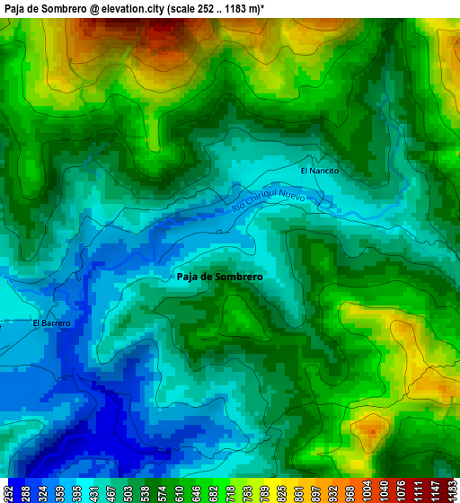
Below is the Elevation map of Paja de Sombrero, which displays elevation range with different colors. Scale of the first map is from 252 to 1183 m (827 to 3881 ft) with average elevation of 552 meters (=1811 ft) [note 1]
These maps also provides idea of topography and contour of this city, they are displayed at different zoom levels. More info about maps, scale and edge coordinates you can find below images.
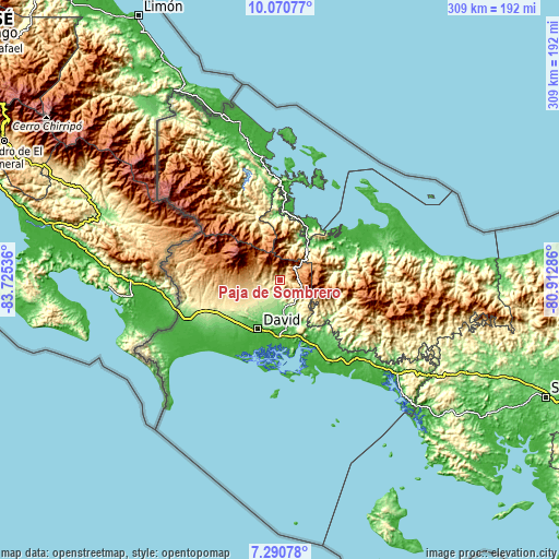
| \ | Map #1 | Topo.Map |
| Scale [m] | 252..1183 m | × |
| Scale [ft] | 827..3881 ft | × |
| Average | 552 m = 1811 ft | × |
| Width | 9.66 km = 6 mi | 309.1 km = 192.1 mi |
| Height | 9.66 km = 6 mi | 309.1 km = 192.1 mi |
| ↑Max Latitude | 8.726789° | 10.07077° |
| Latitude at center | 8.68335° | 8.68335° |
| ↓Min Latitude | 8.639906° | 7.29078° |
| ← Min Longitude | -82.363055° | -83.72536° |
| Longitude center | -82.31911° | -82.31911° |
| →Max Longitude | -82.275165° | -80.91286° |
Nearby cities:
Cities around Paja de Sombrero sort by population:
• Boquete elevation 1131 m
17.2 km,  308°
308°
• Alto Boquete 1031 m
13.7 km,  294°
294°
• Gualaca 121 m
17.2 km,  172°
172°
• Bajo Boquete 1070 m
15.8 km, 307°
• Dolega District 247 m
16.7 km,  218°
218°
• Palmira 1084 m
16.4 km, 290°
• Palmira Centro 1095 m
15.9 km, 293°
• Los Naranjos 1265 m
18.5 km, 310°
• Caldera 370 m
7.8 km,  240°
240°
• Bijagual 122 m
18.8 km,  184°
184°
• Jaramillo Arriba 1276 m
17.2 km,  317°
317°
• Valle de La Mina 807 m
9.8 km,  102°
102°
Multilingual:
 En español:
Paja de Sombrero elevación 402 m.
 En France:
Paja de Sombrero élévation 402 m.
 Auf Deutsch:
Paja de Sombrero höhe über dem Meeresspiegel ist 402 m.

Sources and notes:
- [note 1] Map square and city borders are not equal. Map elevation data is calculated only from area inside that square.
- [src 1] Elevation data from geonames database provided with same terms of usage.
- [src 2] The elevation map of Paja de Sombrero is generated using elevation data from NASA's 3 arcsec (90m) resolution SRTM data.
- [src 3] Base (background) map © OpenStreetMap contributors tiles are generated by Geofabrik and OpenTopoMap.
Copyright & License:
This Paja de Sombrero Elevation Map is licensed under CC BY-SA. You may reuse any part from this page, if you give a proper credit by linking to this URL:
 More info on terms of use page.