Boca del Río Chiriquí elevation
Boca del Río Chiriquí (Ngöbe-Buglé), Panama elevation is -1 meters and Boca del Río Chiriquí elevation in feet is -3 ft above sea level [src 1]. Boca del Río Chiriquí is a seat of a third-order administrative division (feature code) with elevation that is 173 meters (568 ft) smaller than average city elevation in Panama.
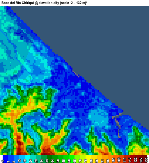
Below is the Elevation map of Boca del Río Chiriquí, which displays elevation range with different colors. Scale of the first map is from -2 to 132 m (-7 to 433 ft) with average elevation of 27.6 meters (=91 ft) [note 1]
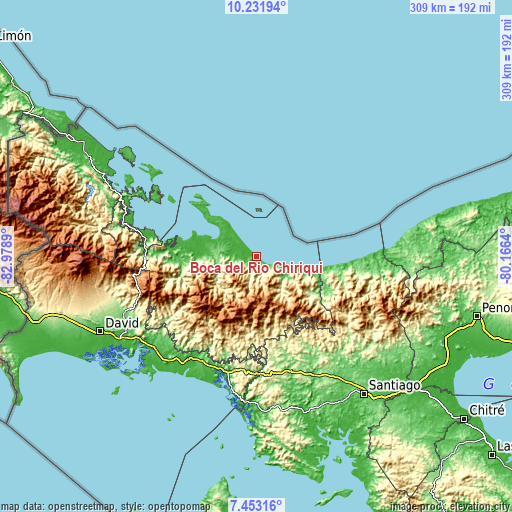
These maps also provides idea of topography and contour of this city, they are displayed at different zoom levels. More info about maps, scale and edge coordinates you can find below images.
| \ | Map #1 | Topo.Map |
| Scale [m] | -2..132 m | × |
| Scale [ft] | -7..433 ft | × |
| Average | 27.6 m = 91 ft | × |
| Width | 9.66 km = 6 mi | 309 km = 192 mi |
| Height | 9.66 km = 6 mi | 309 km = 192 mi |
| ↑Max Latitude | 8.88859° | 10.23194° |
| Latitude at center | 8.84517° | 8.84517° |
| ↓Min Latitude | 8.801745° | 7.45316° |
| ← Min Longitude | -81.616595° | -82.9789° |
| Longitude center | -81.57265° | -81.57265° |
| →Max Longitude | -81.528705° | -80.1664° |
Nearby cities:
Cities around Boca del Río Chiriquí sort by population:
• Bisira elevation 16 m
31.4 km,  280°
280°
• Kankintú 85 m
26.6 km,  269°
269°
• Guayabito 1119 m
35.4 km,  163°
163°
• Cerro Plata 845 m
41 km,  175°
175°
• Calovébora 23 m
40.3 km,  99°
99°
• Loma Yuca 325 m
23.2 km,  127°
127°
• Río Grande 329 m
40.1 km, 128°
• Agua de Salud 629 m
39.7 km, 162°
• Piedra Roja 788 m
36.1 km,  212°
212°
• Mirones 996 m
36.1 km, 207°
• Cuoronte 396 m
30.1 km,  231°
231°
• Santa Catalina 7 m
27.8 km, 104°
Multilingual:
 En español:
Boca del Río Chiriquí elevación -1 m.
 En France:
Boca del Río Chiriquí élévation -1 m.
 Auf Deutsch:
Boca del Río Chiriquí höhe über dem Meeresspiegel ist -1 m.
 На русском:
Boca del Río Chiriquí высота над уровнем моря -1 м
Sources and notes:
- [note 1] Map square and city borders are not equal. Map elevation data is calculated only from area inside that square.
- [src 1] Elevation data from geonames database provided with same terms of usage.
- [src 2] The elevation map of Boca del Río Chiriquí is generated using elevation data from NASA's 3 arcsec (90m) resolution SRTM data.
- [src 3] Base (background) map © OpenStreetMap contributors tiles are generated by Geofabrik and OpenTopoMap.
Copyright & License:
This Boca del Río Chiriquí Elevation Map is licensed under CC BY-SA. You may reuse any part from this page, if you give a proper credit by linking to this URL:
 More info on terms of use page.