San Bartolo elevation
San Bartolo (Veraguas), Panama elevation is 83 meters and San Bartolo elevation in feet is 272 ft above sea level [src 1]. San Bartolo is a seat of a third-order administrative division (feature code) with elevation that is 89 meters (292 ft) smaller than average city elevation in Panama.
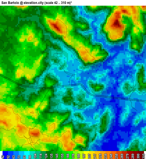
Below is the Elevation map of San Bartolo, which displays elevation range with different colors. Scale of the first map is from 42 to 310 m (138 to 1017 ft) with average elevation of 131.5 meters (=431 ft) [note 1]
These maps also provides idea of topography and contour of this city, they are displayed at different zoom levels. More info about maps, scale and edge coordinates you can find below images.
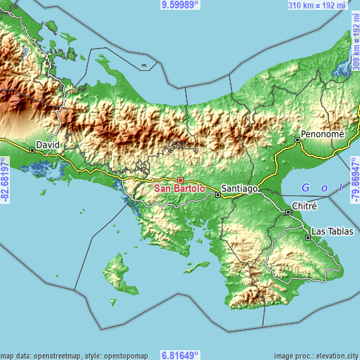
| \ | Map #1 | Topo.Map |
| Scale [m] | 42..310 m | × |
| Scale [ft] | 138..1017 ft | × |
| Average | 131.5 m = 431 ft | × |
| Width | 9.67 km = 6 mi | 309.5 km = 192.3 mi |
| Height | 9.67 km = 6 mi | 309.5 km = 192.3 mi |
| ↑Max Latitude | 8.254122° | 9.59989° |
| Latitude at center | 8.21063° | 8.21063° |
| ↓Min Latitude | 8.167133° | 6.81649° |
| ← Min Longitude | -81.319665° | -82.68197° |
| Longitude center | -81.27572° | -81.27572° |
| →Max Longitude | -81.231775° | -79.86947° |
Nearby cities:
Cities around San Bartolo sort by population:
• Cañazas elevation 201 m
14.1 km,  30°
30°
• La Mesa 206 m
12.6 km,  124°
124°
• San Francisco 47 m
18.9 km,  212°
212°
• Boró 189 m
5.4 km, 210°
• El Rincón 225 m
17.6 km,  260°
260°
• El Marañón 73 m
20.6 km,  160°
160°
• El Picador 467 m
18.7 km,  6°
6°
• Bisvalles 76 m
6.8 km, 117°
• Rodeo Viejo 77 m
11.9 km,  202°
202°
• San Marcelo 136 m
14.5 km,  61°
61°
• El Bale 307 m
18.8 km,  330°
330°
• Cerro de Plata 138 m
13.3 km,  310°
310°
Multilingual:
 En español:
San Bartolo elevación 83 m.
 En France:
San Bartolo élévation 83 m.
 Auf Deutsch:
San Bartolo höhe über dem Meeresspiegel ist 83 m.

Sources and notes:
- [note 1] Map square and city borders are not equal. Map elevation data is calculated only from area inside that square.
- [src 1] Elevation data from geonames database provided with same terms of usage.
- [src 2] The elevation map of San Bartolo is generated using elevation data from NASA's 3 arcsec (90m) resolution SRTM data.
- [src 3] Base (background) map © OpenStreetMap contributors tiles are generated by Geofabrik and OpenTopoMap.
Copyright & License:
This San Bartolo Elevation Map is licensed under CC BY-SA. You may reuse any part from this page, if you give a proper credit by linking to this URL:
 More info on terms of use page.