San Marcelo elevation
San Marcelo (Veraguas), Panama elevation is 136 meters and San Marcelo elevation in feet is 446 ft above sea level [src 1]. San Marcelo is a seat of a third-order administrative division (feature code) with elevation that is 36 meters (118 ft) smaller than average city elevation in Panama.
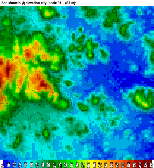
Below is the Elevation map of San Marcelo, which displays elevation range with different colors. Scale of the first map is from 91 to 437 m (299 to 1434 ft) with average elevation of 174.2 meters (=572 ft) [note 1]
These maps also provides idea of topography and contour of this city, they are displayed at different zoom levels. More info about maps, scale and edge coordinates you can find below images.
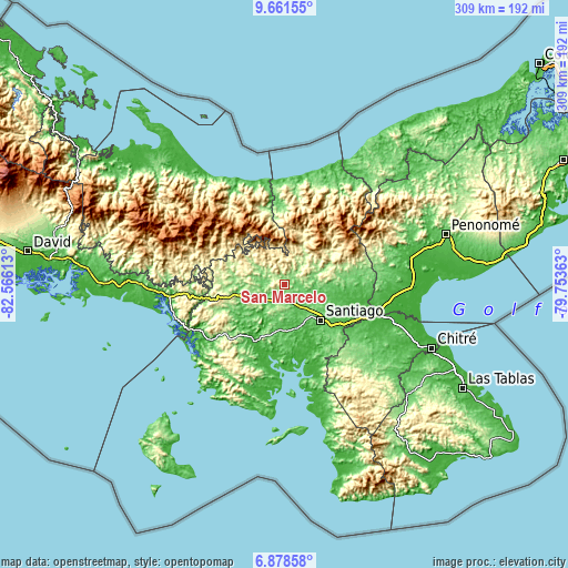
| \ | Map #1 | Topo.Map |
| Scale [m] | 91..437 m | × |
| Scale [ft] | 299..1434 ft | × |
| Average | 174.2 m = 572 ft | × |
| Width | 9.67 km = 6 mi | 309.4 km = 192.3 mi |
| Height | 9.67 km = 6 mi | 309.5 km = 192.3 mi |
| ↑Max Latitude | 8.316006° | 9.66155° |
| Latitude at center | 8.27252° | 8.27252° |
| ↓Min Latitude | 8.22903° | 6.87858° |
| ← Min Longitude | -81.203825° | -82.56613° |
| Longitude center | -81.15988° | -81.15988° |
| →Max Longitude | -81.115935° | -79.75363° |
Nearby cities:
Cities around San Marcelo sort by population:
• Cañazas elevation 201 m
7.8 km,  312°
312°
• La Mesa 206 m
14.1 km,  189°
189°
• San Francisco 88 m
20.6 km,  98°
98°
• San Pedro del Espino 63 m
16.8 km,  151°
151°
• Boró 189 m
19.3 km,  233°
233°
• San Juan 98 m
16.2 km,  77°
77°
• El Picador 467 m
15.8 km,  317°
317°
• San Bartolo 83 m
14.5 km,  241°
241°
• Bisvalles 76 m
12 km,  214°
214°
• Calabacito 104 m
9 km,  107°
107°
• Los Valles 391 m
20 km,  347°
347°
• Los Corotúes 324 m
17.5 km,  20°
20°
Multilingual:
 En español:
San Marcelo elevación 136 m.
 En France:
San Marcelo élévation 136 m.
 Auf Deutsch:
San Marcelo höhe über dem Meeresspiegel ist 136 m.

Sources and notes:
- [note 1] Map square and city borders are not equal. Map elevation data is calculated only from area inside that square.
- [src 1] Elevation data from geonames database provided with same terms of usage.
- [src 2] The elevation map of San Marcelo is generated using elevation data from NASA's 3 arcsec (90m) resolution SRTM data.
- [src 3] Base (background) map © OpenStreetMap contributors tiles are generated by Geofabrik and OpenTopoMap.
Copyright & License:
This San Marcelo Elevation Map is licensed under CC BY-SA. You may reuse any part from this page, if you give a proper credit by linking to this URL:
 More info on terms of use page.