El Bale elevation
El Bale (Veraguas), Panama elevation is 307 meters and El Bale elevation in feet is 1007 ft above sea level [src 1]. El Bale is a seat of a third-order administrative division (feature code) with elevation that is 135 meters (443 ft) bigger than average city elevation in Panama.
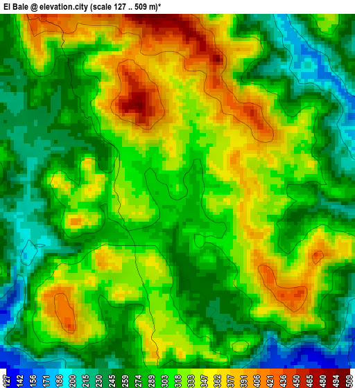
Below is the Elevation map of El Bale, which displays elevation range with different colors. Scale of the first map is from 127 to 509 m (417 to 1670 ft) with average elevation of 302.6 meters (=993 ft) [note 1]
These maps also provides idea of topography and contour of this city, they are displayed at different zoom levels. More info about maps, scale and edge coordinates you can find below images.
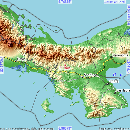
| \ | Map #1 | Topo.Map |
| Scale [m] | 127..509 m | × |
| Scale [ft] | 417..1670 ft | × |
| Average | 302.6 m = 993 ft | × |
| Width | 9.67 km = 6 mi | 309.4 km = 192.3 mi |
| Height | 9.67 km = 6 mi | 309.4 km = 192.3 mi |
| ↑Max Latitude | 8.400926° | 9.74615° |
| Latitude at center | 8.35745° | 8.35745° |
| ↓Min Latitude | 8.313969° | 6.96379° |
| ← Min Longitude | -81.404935° | -82.76724° |
| Longitude center | -81.36099° | -81.36099° |
| →Max Longitude | -81.317045° | -79.95474° |
Nearby cities:
Cities around El Bale sort by population:
• Cañazas elevation 201 m
17 km,  104°
104°
• Buenos Aires 336 m
15 km,  294°
294°
• Alto de Jesús 338 m
17.2 km,  231°
231°
• El Picador 467 m
11.8 km,  78°
78°
• San Bartolo 83 m
18.8 km,  150°
150°
• Viguí 274 m
15.2 km,  262°
262°
• Los Valles 391 m
20.5 km,  60°
60°
• Agua de Salud 629 m
19.9 km,  325°
325°
• Bajo Solis 272 m
18.5 km,  266°
266°
• Güibale 772 m
17.2 km,  359°
359°
• Cerro de Plata 138 m
7.8 km,  186°
186°
• San José 231 m
5.1 km, 289°
Multilingual:
 En español:
El Bale elevación 307 m.
 En France:
El Bale élévation 307 m.


Sources and notes:
- [note 1] Map square and city borders are not equal. Map elevation data is calculated only from area inside that square.
- [src 1] Elevation data from geonames database provided with same terms of usage.
- [src 2] The elevation map of El Bale is generated using elevation data from NASA's 3 arcsec (90m) resolution SRTM data.
- [src 3] Base (background) map © OpenStreetMap contributors tiles are generated by Geofabrik and OpenTopoMap.
Copyright & License:
This El Bale Elevation Map is licensed under CC BY-SA. You may reuse any part from this page, if you give a proper credit by linking to this URL:
 More info on terms of use page.