Haymā’ elevation
Haymā’ (Al Wusţá), Oman elevation is 135 meters and Haymā’ elevation in feet is 443 ft above sea level [src 1]. Haymā’ is a seat of a first-order administrative division (feature code) with elevation that is 72 meters (236 ft) smaller than average city elevation in Oman.
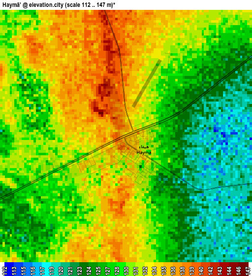
Below is the Elevation map of Haymā’, which displays elevation range with different colors. Scale of the first map is from 112 to 147 m (367 to 482 ft) with average elevation of 129.4 meters (=425 ft) [note 1]
These maps also provides idea of topography and contour of this city, they are displayed at different zoom levels. More info about maps, scale and edge coordinates you can find below images.
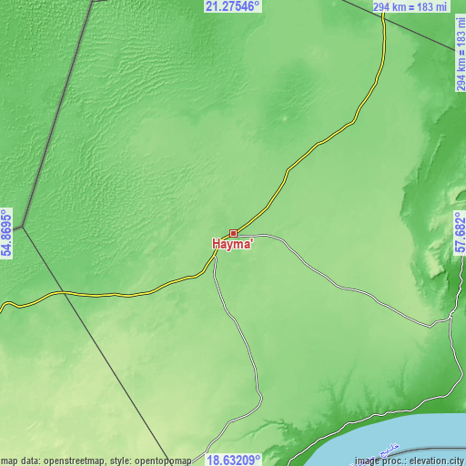
| \ | Map #1 | Topo.Map |
| Scale [m] | 112..147 m | × |
| Scale [ft] | 367..482 ft | × |
| Average | 129.4 m = 425 ft | × |
| Width | 9.19 km = 5.7 mi | 293.9 km = 182.6 mi |
| Height | 9.19 km = 5.7 mi | 293.9 km = 182.6 mi |
| ↑Max Latitude | 20.00061° | 21.27546° |
| Latitude at center | 19.95931° | 19.95931° |
| ↓Min Latitude | 19.917999° | 18.63209° |
| ← Min Longitude | 56.231805° | 54.8695° |
| Longitude center | 56.27575° | 56.27575° |
| →Max Longitude | 56.319695° | 57.682° |
Nearby cities:
Cities around Haymā’ sort by population:
• Şalālah elevation 13 m
400.2 km,  215°
215°
• ‘Ibrī 359 m
364 km,  3°
3°
• Rustaq 341 m
399.6 km,  17°
17°
• Nizwá 511 m
355.4 km, 21°
• Bahlā’ 567 m
352.2 km, 17°
• Izkī 547 m
364.9 km,  25°
25°
• Ibrā’ 446 m
383.3 km,  37°
37°
• Badīyah 298 m
381 km, 43°
• Adam 274 m
298.7 km, 25°
• Yanqul 684 m
404.2 km, 3°
• Al Qābil 343 m
383.6 km, 40°
• Bayt al ‘Awābī 493 m
393.6 km, 19°
Multilingual:
 En español:
Haymā’ elevación 135 m.
 En France:
Haymā’ élévation 135 m.


Sources and notes:
- [note 1] Map square and city borders are not equal. Map elevation data is calculated only from area inside that square.
- [src 1] Elevation data from geonames database provided with same terms of usage.
- [src 2] The elevation map of Haymā’ is generated using elevation data from NASA's 3 arcsec (90m) resolution SRTM data.
- [src 3] Base (background) map © OpenStreetMap contributors tiles are generated by Geofabrik and OpenTopoMap.
Copyright & License:
This Haymā’ Elevation Map is licensed under CC BY-SA. You may reuse any part from this page, if you give a proper credit by linking to this URL:
 More info on terms of use page.