Waitara elevation
Waitara (Taranaki, New Plymouth District), New Zealand elevation is 8 meters and Waitara elevation in feet is 26 ft above sea level [src 1]. Waitara is a populated place (feature code) with elevation that is 69 meters (226 ft) smaller than average city elevation in New Zealand.
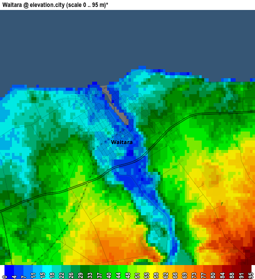
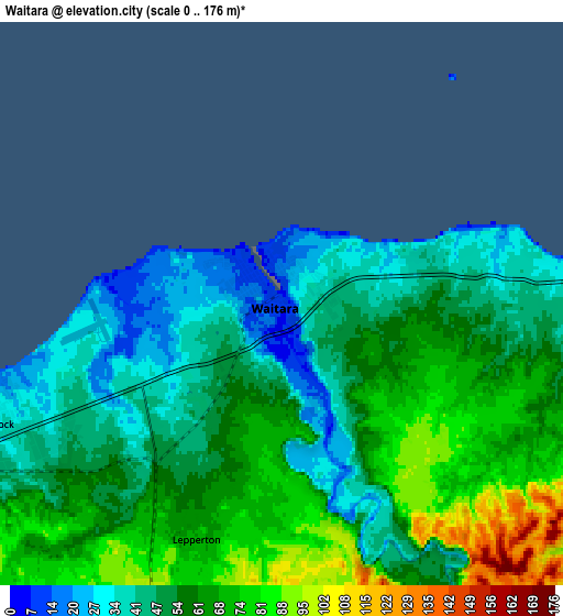
Below is the Elevation map of Waitara, which displays elevation range with different colors. Scale of the first map is from 0 to 95 m (0 to 312 ft) with average elevation of 37.9 meters (=124 ft) [note 1]
These maps also provides idea of topography and contour of this city, they are displayed at different zoom levels. More info about maps, scale and edge coordinates you can find below images.
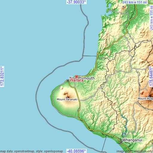
| \ | Map #1 | Map #2 | Topo.Map |
| Scale [m] | 0..95 m | 0..176 m | × |
| Scale [ft] | 0..312 ft | 0..577 ft | × |
| Average | 37.9 m = 124 ft | 56.7 m = 186 ft | × |
| Width | 7.59 km = 4.7 mi | 15.19 km = 9.4 mi | 243 km = 151 mi |
| Height | 7.59 km = 4.7 mi | 15.19 km = 9.4 mi | 243 km = 151 mi |
| ↑Max Latitude | -38.967421° | -38.933245° | -37.90033° |
| Latitude at center | -39.00158° | -39.00158° | -39.00158° |
| ↓Min Latitude | -39.035723° | -39.069849° | -40.08596° |
| ← Min Longitude | 174.194415° | 174.150469° | 172.83211° |
| Longitude center | 174.23836° | 174.23836° | 174.23836° |
| →Max Longitude | 174.282305° | 174.326251° | 175.64461° |
Nearby cities:
Cities around Waitara sort by population:
• Hamilton elevation 39 m
163.2 km,  33°
33°
• New Plymouth 64 m
15.2 km,  241°
241°
• Wanganui 18 m
124.8 km,  146°
146°
• Cambridge 67 m
163 km,  39°
39°
• Hawera 110 m
65.7 km,  176°
176°
• Turangi 383 m
135.7 km,  89°
89°
• Raglan 31 m
144.9 km,  22°
22°
• Otorohanga 39 m
123.5 km, 42°
• Eltham 219 m
47.8 km,  173°
173°
• Opunake 32 m
60.2 km,  212°
212°
• Waiouru 819 m
134 km,  113°
113°
• Patea 10 m
86.7 km, 165°
Multilingual:
 En español:
Waitara elevación 8 m.
 En France:
Waitara élévation 8 m.


Sources and notes:
- [note 1] Map square and city borders are not equal. Map elevation data is calculated only from area inside that square.
- [src 1] Elevation data from geonames database provided with same terms of usage.
- [src 2] The elevation map of Waitara is generated using elevation data from NASA's 3 arcsec (90m) resolution SRTM data.
- [src 3] Base (background) map © OpenStreetMap contributors tiles are generated by Geofabrik and OpenTopoMap.
Copyright & License:
This Waitara Elevation Map is licensed under CC BY-SA. You may reuse any part from this page, if you give a proper credit by linking to this URL:
 More info on terms of use page.