Hawera elevation
Hawera (Taranaki, South Taranaki District), New Zealand elevation is 110 meters and Hawera elevation in feet is 361 ft above sea level [src 1]. Hawera is a populated place (feature code) with elevation that is 33 meters (108 ft) bigger than average city elevation in New Zealand.
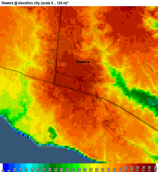
Below is the Elevation map of Hawera, which displays elevation range with different colors. Scale of the first map is from 0 to 124 m (0 to 407 ft) with average elevation of 89.9 meters (=295 ft) [note 1]
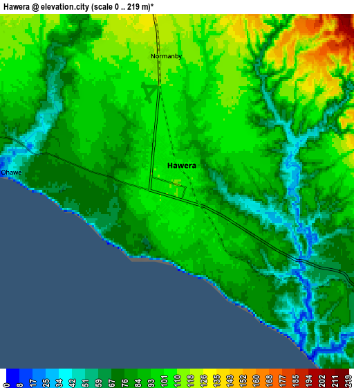
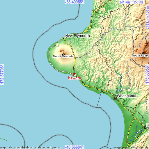
These maps also provides idea of topography and contour of this city, they are displayed at different zoom levels. More info about maps, scale and edge coordinates you can find below images.
| \ | Map #1 | Map #2 | Topo.Map |
| Scale [m] | 0..124 m | 0..219 m | × |
| Scale [ft] | 0..407 ft | 0..719 ft | × |
| Average | 89.9 m = 295 ft | 89.5 m = 294 ft | × |
| Width | 7.53 km = 4.7 mi | 15.06 km = 9.4 mi | 241 km = 149.8 mi |
| Height | 7.53 km = 4.7 mi | 15.06 km = 9.4 mi | 241 km = 149.8 mi |
| ↑Max Latitude | -39.557797° | -39.523908° | -38.49955° |
| Latitude at center | -39.59167° | -39.59167° | -39.59167° |
| ↓Min Latitude | -39.625526° | -39.659366° | -40.66684° |
| ← Min Longitude | 174.239385° | 174.195439° | 172.87708° |
| Longitude center | 174.28333° | 174.28333° | 174.28333° |
| →Max Longitude | 174.327275° | 174.371221° | 175.68958° |
Nearby cities:
Cities around Hawera sort by population:
• Palmerston North elevation 34 m
141.5 km,  126°
126°
• New Plymouth 64 m
60.9 km,  343°
343°
• Wanganui 18 m
75.7 km,  120°
120°
• Levin 38 m
143.3 km,  143°
143°
• Waitara 8 m
65.7 km,  356°
356°
• Foxton 16 m
130.2 km, 138°
• Eltham 219 m
18.1 km,  4°
4°
• Bulls 55 m
114.2 km, 124°
• Opunake 32 m
39.5 km,  292°
292°
• Waiouru 819 m
119.4 km,  83°
83°
• Patea 10 m
25.2 km, 137°
• Linton Military Camp 24 m
142.8 km, 129°
Multilingual:
 En español:
Hawera elevación 110 m.
 En France:
Hawera élévation 110 m.


Sources and notes:
- [note 1] Map square and city borders are not equal. Map elevation data is calculated only from area inside that square.
- [src 1] Elevation data from geonames database provided with same terms of usage.
- [src 2] The elevation map of Hawera is generated using elevation data from NASA's 3 arcsec (90m) resolution SRTM data.
- [src 3] Base (background) map © OpenStreetMap contributors tiles are generated by Geofabrik and OpenTopoMap.
Copyright & License:
This Hawera Elevation Map is licensed under CC BY-SA. You may reuse any part from this page, if you give a proper credit by linking to this URL:
 More info on terms of use page.