Rāmechhāp elevation
Rāmechhāp (Central Region, Janakpur Zone), Nepal elevation is 1258 meters and Rāmechhāp elevation in feet is 4127 ft above sea level [src 1]. Rāmechhāp is a seat of a third-order administrative division (feature code) with elevation that is 299 meters (981 ft) bigger than average city elevation in Nepal.
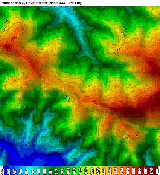
Below is the Elevation map of Rāmechhāp, which displays elevation range with different colors. Scale of the first map is from 443 to 1801 m (1453 to 5909 ft) with average elevation of 1103.3 meters (=3620 ft) [note 1]
These maps also provides idea of topography and contour of this city, they are displayed at different zoom levels. More info about maps, scale and edge coordinates you can find below images.
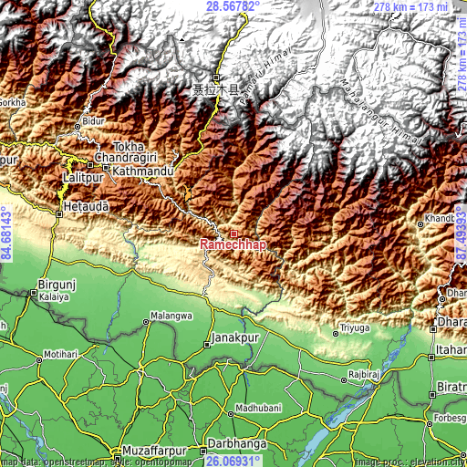
| \ | Map #1 | Topo.Map |
| Scale [m] | 443..1801 m | × |
| Scale [ft] | 1453..5909 ft | × |
| Average | 1103.3 m = 3620 ft | × |
| Width | 8.68 km = 5.4 mi | 277.8 km = 172.6 mi |
| Height | 8.68 km = 5.4 mi | 277.8 km = 172.6 mi |
| ↑Max Latitude | 27.364635° | 28.56782° |
| Latitude at center | 27.3256° | 27.3256° |
| ↓Min Latitude | 27.286552° | 26.06931° |
| ← Min Longitude | 86.043735° | 84.68143° |
| Longitude center | 86.08768° | 86.08768° |
| →Max Longitude | 86.131625° | 87.49393° |
Nearby cities:
Cities around Rāmechhāp sort by population:
• Janakpur elevation 83 m
68.3 km,  193°
193°
• Panauti 1440 m
62.9 km,  297°
297°
• Panauti̇̄ 1455 m
63.4 km, 296°
• Siraha 82 m
75.6 km,  170°
170°
• Malaṅgawā 89 m
73.9 km,  225°
225°
• Banepā 1477 m
65.4 km, 301°
• Dhulikhel 1484 m
63.1 km, 301°
• Hari Bdr Tamang House 1703 m
70.6 km, 298°
• kankrabari Dovan 1703 m
70.6 km, 298°
• Nagarkot 1905 m
70.7 km,  307°
307°
• Kothari 1629 m
71.8 km,  349°
349°
• Bhaktapur 1348 m
75.5 km, 300°
Multilingual:
 En español:
Rāmechhāp elevación 1258 m.
 En France:
Rāmechhāp élévation 1258 m.
 Auf Deutsch:
Rāmechhāp höhe über dem Meeresspiegel ist 1258 m.

Sources and notes:
- [note 1] Map square and city borders are not equal. Map elevation data is calculated only from area inside that square.
- [src 1] Elevation data from geonames database provided with same terms of usage.
- [src 2] The elevation map of Rāmechhāp is generated using elevation data from NASA's 3 arcsec (90m) resolution SRTM data.
- [src 3] Base (background) map © OpenStreetMap contributors tiles are generated by Geofabrik and OpenTopoMap.
Copyright & License:
This Rāmechhāp Elevation Map is licensed under CC BY-SA. You may reuse any part from this page, if you give a proper credit by linking to this URL:
 More info on terms of use page.