Tānsen elevation
Tānsen (Western Region), Nepal elevation is 1303 meters and Tānsen elevation in feet is 4275 ft above sea level [src 1]. Tānsen is a populated place (feature code) with elevation that is 344 meters (1129 ft) bigger than average city elevation in Nepal.
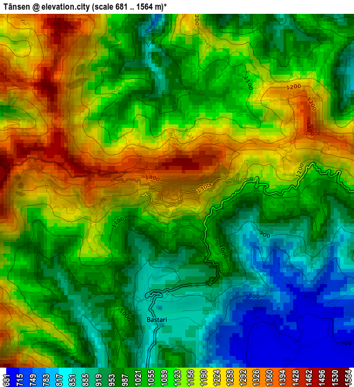
Below is the Elevation map of Tānsen, which displays elevation range with different colors. Scale of the first map is from 681 to 1564 m (2234 to 5131 ft) with average elevation of 1071.1 meters (=3514 ft) [note 1]
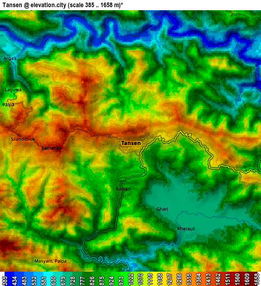
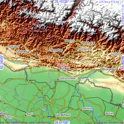
These maps also provides idea of topography and contour of this city, they are displayed at different zoom levels. More info about maps, scale and edge coordinates you can find below images.
| \ | Map #1 | Map #2 | Topo.Map |
| Scale [m] | 681..1564 m | 385..1658 m | × |
| Scale [ft] | 2234..5131 ft | 1263..5440 ft | × |
| Average | 1071.1 m = 3514 ft | 959.2 m = 3147 ft | × |
| Width | 8.64 km = 5.4 mi | 17.28 km = 10.7 mi | 276.4 km = 171.7 mi |
| Height | 8.64 km = 5.4 mi | 17.28 km = 10.7 mi | 276.4 km = 171.7 mi |
| ↑Max Latitude | 27.906152° | 27.94498° | 29.10328° |
| Latitude at center | 27.86731° | 27.86731° | 27.86731° |
| ↓Min Latitude | 27.828454° | 27.789584° | 26.61708° |
| ← Min Longitude | 83.502755° | 83.458809° | 82.14045° |
| Longitude center | 83.5467° | 83.5467° | 83.5467° |
| →Max Longitude | 83.590645° | 83.634591° | 84.95295° |
Nearby cities:
Cities around Tānsen sort by population:
• Pokhara elevation 1008 m
60.7 km,  42°
42°
• Bharatpur 212 m
90 km,  103°
103°
• Butwāl 322 m
20.9 km,  207°
207°
• Siddharthanagar 107 m
41.9 km,  193°
193°
• Bāglung 1212 m
45.2 km,  5°
5°
• Wāliṅ 722 m
24.6 km,  58°
58°
• Bhattarai Danda 436 m
38 km,  87°
87°
• Besisahar 1334 m
118.5 km,  290°
290°
• Chitre 2311 m
63.8 km, 12°
• Dihi 374 m
37.4 km, 88°
• Lamjung 1420 m
88.8 km, 64°
• Pyūthān 1336 m
69.5 km, 290°
Multilingual:
 En español:
Tānsen elevación 1303 m.
 En France:
Tānsen élévation 1303 m.


Sources and notes:
- [note 1] Map square and city borders are not equal. Map elevation data is calculated only from area inside that square.
- [src 1] Elevation data from geonames database provided with same terms of usage.
- [src 2] The elevation map of Tānsen is generated using elevation data from NASA's 3 arcsec (90m) resolution SRTM data.
- [src 3] Base (background) map © OpenStreetMap contributors tiles are generated by Geofabrik and OpenTopoMap.
Copyright & License:
This Tānsen Elevation Map is licensed under CC BY-SA. You may reuse any part from this page, if you give a proper credit by linking to this URL:
 More info on terms of use page.