Besisahar elevation
Besisahar, Nepal elevation is 1334 meters and Besisahar elevation in feet is 4377 ft above sea level [src 1]. Besisahar is a populated place (feature code) with elevation that is 375 meters (1230 ft) bigger than average city elevation in Nepal.
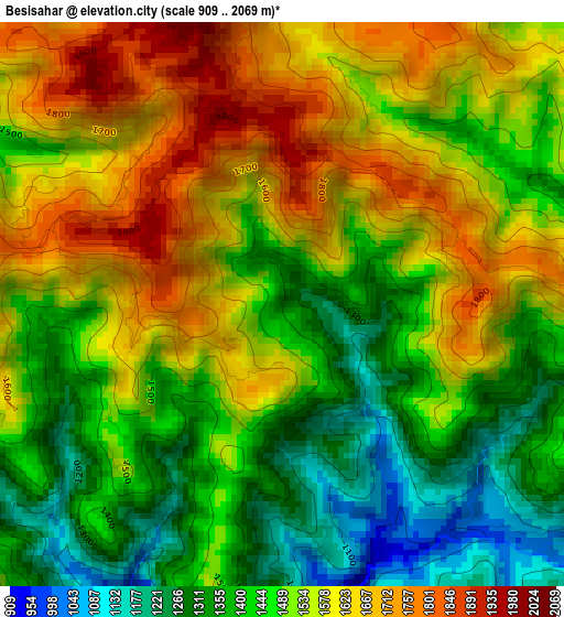
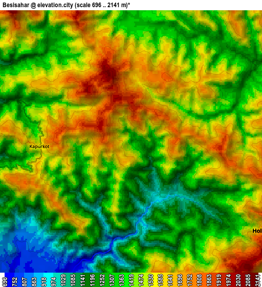
Below is the Elevation map of Besisahar, which displays elevation range with different colors. Scale of the first map is from 909 to 2069 m (2982 to 6788 ft) with average elevation of 1505.5 meters (=4939 ft) [note 1]
These maps also provides idea of topography and contour of this city, they are displayed at different zoom levels. More info about maps, scale and edge coordinates you can find below images.
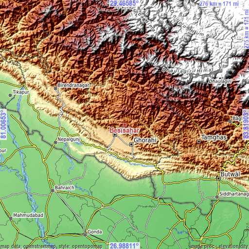
| \ | Map #1 | Map #2 | Topo.Map |
| Scale [m] | 909..2069 m | 696..2141 m | × |
| Scale [ft] | 2982..6788 ft | 2283..7024 ft | × |
| Average | 1505.5 m = 4939 ft | 1429.9 m = 4691 ft | × |
| Width | 8.61 km = 5.3 mi | 17.22 km = 10.7 mi | 275.5 km = 171.2 mi |
| Height | 8.61 km = 5.3 mi | 17.22 km = 10.7 mi | 275.5 km = 171.2 mi |
| ↑Max Latitude | 28.27288° | 28.311575° | 29.46585° |
| Latitude at center | 28.23417° | 28.23417° | 28.23417° |
| ↓Min Latitude | 28.195446° | 28.156708° | 26.98811° |
| ← Min Longitude | 82.368835° | 82.324889° | 81.00653° |
| Longitude center | 82.41278° | 82.41278° | 82.41278° |
| →Max Longitude | 82.456725° | 82.500671° | 83.81903° |
Nearby cities:
Cities around Besisahar sort by population:
• Butwāl elevation 322 m
117.7 km,  120°
120°
• Nepalgunj 150 m
80.7 km,  255°
255°
• Gulariyā 141 m
104.6 km,  268°
268°
• Tulsīpur 675 m
16.1 km,  224°
224°
• Birendranagar 736 m
86.5 km,  298°
298°
• Bāglung 1212 m
115.4 km,  87°
87°
• Dailekh 1307 m
96.5 km,  314°
314°
• Bhojpur 132 m
70.8 km,  242°
242°
• Bardiyā 151 m
104 km, 274°
• Surkhet 874 m
69.6 km, 296°
• Pyūthān 1336 m
49 km,  109°
109°
• Salyān 1468 m
28.7 km, 304°
Multilingual:
 En español:
Besisahar elevación 1334 m.
 En France:
Besisahar élévation 1334 m.
 Auf Deutsch:
Besisahar höhe über dem Meeresspiegel ist 1334 m.

Sources and notes:
- [note 1] Map square and city borders are not equal. Map elevation data is calculated only from area inside that square.
- [src 1] Elevation data from geonames database provided with same terms of usage.
- [src 2] The elevation map of Besisahar is generated using elevation data from NASA's 3 arcsec (90m) resolution SRTM data.
- [src 3] Base (background) map © OpenStreetMap contributors tiles are generated by Geofabrik and OpenTopoMap.
Copyright & License:
This Besisahar Elevation Map is licensed under CC BY-SA. You may reuse any part from this page, if you give a proper credit by linking to this URL:
 More info on terms of use page.