Birendranagar elevation
Birendranagar (Mid Western), Nepal elevation is 736 meters and Birendranagar elevation in feet is 2415 ft above sea level [src 1]. Birendranagar is a seat of a first-order administrative division (feature code) with elevation that is 223 meters (732 ft) smaller than average city elevation in Nepal.
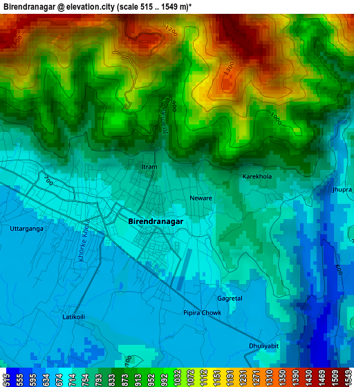
Below is the Elevation map of Birendranagar, which displays elevation range with different colors. Scale of the first map is from 515 to 1549 m (1690 to 5082 ft) with average elevation of 829.5 meters (=2721 ft) [note 1]
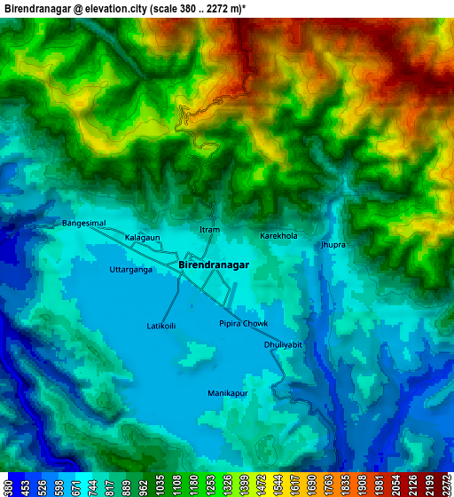
These maps also provides idea of topography and contour of this city, they are displayed at different zoom levels. More info about maps, scale and edge coordinates you can find below images.
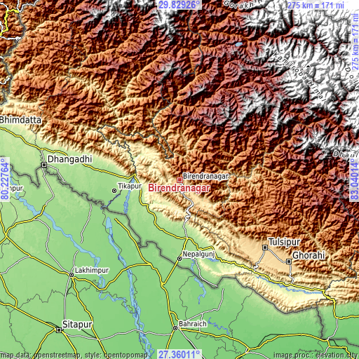
| \ | Map #1 | Map #2 | Topo.Map |
| Scale [m] | 515..1549 m | 380..2272 m | × |
| Scale [ft] | 1690..5082 ft | 1247..7454 ft | × |
| Average | 829.5 m = 2721 ft | 961 m = 3153 ft | × |
| Width | 8.58 km = 5.3 mi | 17.16 km = 10.7 mi | 274.5 km = 170.6 mi |
| Height | 8.58 km = 5.3 mi | 17.16 km = 10.7 mi | 274.6 km = 170.6 mi |
| ↑Max Latitude | 28.640515° | 28.679077° | 29.82926° |
| Latitude at center | 28.60194° | 28.60194° | 28.60194° |
| ↓Min Latitude | 28.56335° | 28.524747° | 27.36011° |
| ← Min Longitude | 81.589945° | 81.545999° | 80.22764° |
| Longitude center | 81.63389° | 81.63389° | 81.63389° |
| →Max Longitude | 81.677835° | 81.721781° | 83.04014° |
Nearby cities:
Cities around Birendranagar sort by population:
• Nepalgunj elevation 150 m
61.4 km,  181°
181°
• Gulariyā 141 m
52.3 km,  212°
212°
• Ṭikāpur 168 m
51 km,  260°
260°
• Tulsīpur 675 m
83.4 km,  128°
128°
• Dailekh 1307 m
28 km,  15°
15°
• Jumla 2354 m
92 km,  35°
35°
• Besisahar 1334 m
86.5 km,  118°
118°
• Bhojpur 132 m
75.4 km,  169°
169°
• Achhām 1284 m
59.5 km,  326°
326°
• Salyān 1468 m
58 km, 115°
• Bardiyā 151 m
43.3 km,  219°
219°
• Surkhet 874 m
17 km, 123°
Multilingual:
 En español:
Birendranagar elevación 736 m.
 En France:
Birendranagar élévation 736 m.
 Auf Deutsch:
Birendranagar höhe über dem Meeresspiegel ist 736 m.

Sources and notes:
- [note 1] Map square and city borders are not equal. Map elevation data is calculated only from area inside that square.
- [src 1] Elevation data from geonames database provided with same terms of usage.
- [src 2] The elevation map of Birendranagar is generated using elevation data from NASA's 3 arcsec (90m) resolution SRTM data.
- [src 3] Base (background) map © OpenStreetMap contributors tiles are generated by Geofabrik and OpenTopoMap.
Copyright & License:
This Birendranagar Elevation Map is licensed under CC BY-SA. You may reuse any part from this page, if you give a proper credit by linking to this URL:
 More info on terms of use page.