Nagarote elevation
Nagarote (León), Nicaragua elevation is 86 meters and Nagarote elevation in feet is 282 ft above sea level [src 1]. Nagarote is a seat of a second-order administrative division (feature code) with elevation that is 255 meters (837 ft) smaller than average city elevation in Nicaragua.
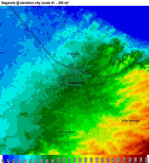
Below is the Elevation map of Nagarote, which displays elevation range with different colors. Scale of the first map is from 41 to 200 m (135 to 656 ft) with average elevation of 88.2 meters (=289 ft) [note 1]
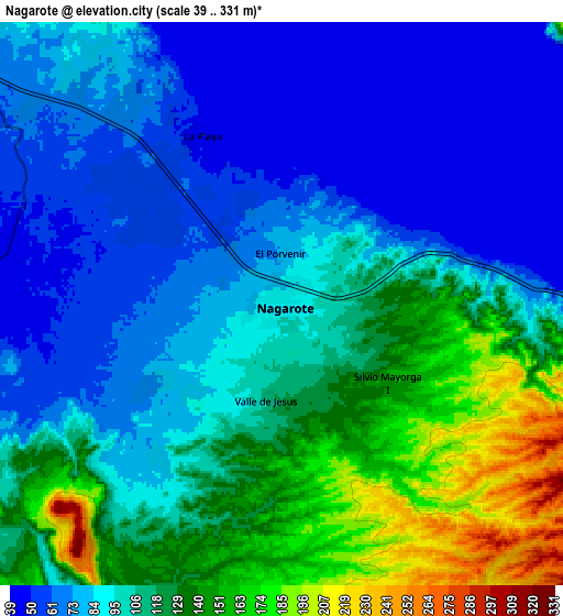
These maps also provides idea of topography and contour of this city, they are displayed at different zoom levels. More info about maps, scale and edge coordinates you can find below images.
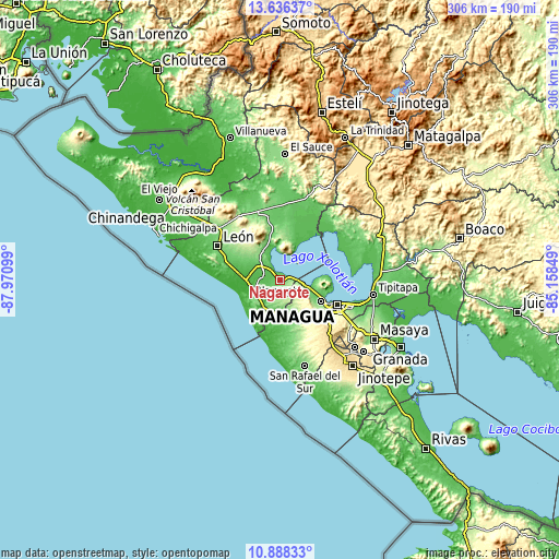
| \ | Map #1 | Map #2 | Topo.Map |
| Scale [m] | 41..200 m | 39..331 m | × |
| Scale [ft] | 135..656 ft | 128..1086 ft | × |
| Average | 88.2 m = 289 ft | 101.2 m = 332 ft | × |
| Width | 9.55 km = 5.9 mi | 19.1 km = 11.9 mi | 305.6 km = 189.9 mi |
| Height | 9.55 km = 5.9 mi | 19.1 km = 11.9 mi | 305.6 km = 189.9 mi |
| ↑Max Latitude | 12.308869° | 12.3518° | 13.63637° |
| Latitude at center | 12.26593° | 12.26593° | 12.26593° |
| ↓Min Latitude | 12.222984° | 12.180032° | 10.88833° |
| ← Min Longitude | -86.608685° | -86.652631° | -87.97099° |
| Longitude center | -86.56474° | -86.56474° | -86.56474° |
| →Max Longitude | -86.520795° | -86.476849° | -85.15849° |
Nearby cities:
Cities around Nagarote sort by population:
• Managua elevation 108 m
37.2 km,  113°
113°
• León 107 m
39 km,  299°
299°
• Ciudad Sandino 105 m
26.8 km,  116°
116°
• La Paz Centro 73 m
14.6 km, 304°
• El Crucero 930 m
41.4 km,  137°
137°
• Telica 131 m
42.8 km,  311°
311°
• Villa El Carmen 107 m
32.4 km,  168°
168°
• Valle San Francisco 110 m
41.4 km,  47°
47°
• Quezalguaque 98 m
45.5 km, 306°
• San Francisco Libre 50 m
39.2 km, 47°
• Malpaisillo 119 m
38.5 km,  341°
341°
• Mateare 60 m
15.2 km,  102°
102°
Multilingual:
 En español:
Nagarote elevación 86 m.
 En France:
Nagarote élévation 86 m.


Sources and notes:
- [note 1] Map square and city borders are not equal. Map elevation data is calculated only from area inside that square.
- [src 1] Elevation data from geonames database provided with same terms of usage.
- [src 2] The elevation map of Nagarote is generated using elevation data from NASA's 3 arcsec (90m) resolution SRTM data.
- [src 3] Base (background) map © OpenStreetMap contributors tiles are generated by Geofabrik and OpenTopoMap.
Copyright & License:
This Nagarote Elevation Map is licensed under CC BY-SA. You may reuse any part from this page, if you give a proper credit by linking to this URL:
 More info on terms of use page.