Managua elevation
Managua, Nicaragua elevation is 108 meters and Managua elevation in feet is 354 ft above sea level [src 1]. Managua is a capital of a political entity (feature code) with elevation that is 233 meters (764 ft) smaller than average city elevation in Nicaragua.
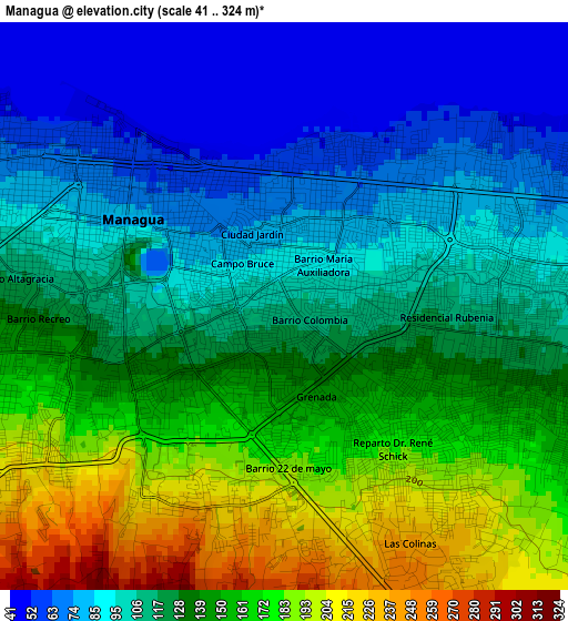
Below is the Elevation map of Managua, which displays elevation range with different colors. Scale of the first map is from 41 to 324 m (135 to 1063 ft) with average elevation of 125.5 meters (=412 ft) [note 1]
These maps also provides idea of topography and contour of this city, they are displayed at different zoom levels. More info about maps, scale and edge coordinates you can find below images.
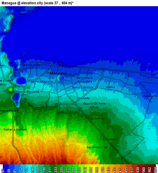
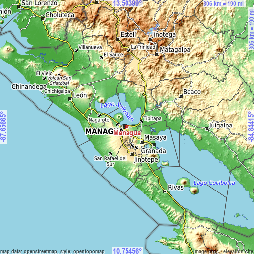
| \ | Map #1 | Map #2 | Topo.Map |
| Scale [m] | 41..324 m | 37..604 m | × |
| Scale [ft] | 135..1063 ft | 121..1982 ft | × |
| Average | 125.5 m = 412 ft | 153.7 m = 504 ft | × |
| Width | 9.55 km = 5.9 mi | 19.11 km = 11.9 mi | 305.7 km = 190 mi |
| Height | 9.55 km = 5.9 mi | 19.11 km = 11.9 mi | 305.7 km = 190 mi |
| ↑Max Latitude | 12.17578° | 12.218734° | 13.50399° |
| Latitude at center | 12.13282° | 12.13282° | 12.13282° |
| ↓Min Latitude | 12.089853° | 12.046879° | 10.75456° |
| ← Min Longitude | -86.294345° | -86.338291° | -87.65665° |
| Longitude center | -86.2504° | -86.2504° | -86.2504° |
| →Max Longitude | -86.206455° | -86.162509° | -84.84415° |
Nearby cities:
Cities around Managua sort by population:
• Masaya elevation 239 m
24.5 km,  136°
136°
• Tipitapa 54 m
18.1 km,  66°
66°
• Ciudad Sandino 105 m
10.6 km,  285°
285°
• San Marcos 554 m
25.4 km,  168°
168°
• Masatepe 454 m
26.9 km,  154°
154°
• El Crucero 930 m
17.1 km,  202°
202°
• Ticuantepe 302 m
13.2 km,  158°
158°
• Nindirí 223 m
20.1 km, 135°
• La Concepción 538 m
22.7 km, 163°
• Nandasmo 425 m
27.2 km, 148°
• Tisma 53 m
26 km,  102°
102°
• Mateare 60 m
22.4 km,  300°
300°
Multilingual:
 En español:
Managua elevación 108 m.
 En France:
Managua élévation 108 m.


Sources and notes:
- [note 1] Map square and city borders are not equal. Map elevation data is calculated only from area inside that square.
- [src 1] Elevation data from geonames database provided with same terms of usage.
- [src 2] The elevation map of Managua is generated using elevation data from NASA's 3 arcsec (90m) resolution SRTM data.
- [src 3] Base (background) map © OpenStreetMap contributors tiles are generated by Geofabrik and OpenTopoMap.
Copyright & License:
This Managua Elevation Map is licensed under CC BY-SA. You may reuse any part from this page, if you give a proper credit by linking to this URL:
 More info on terms of use page.