Telica elevation
Telica (León), Nicaragua elevation is 131 meters and Telica elevation in feet is 430 ft above sea level [src 1]. Telica is a seat of a second-order administrative division (feature code) with elevation that is 210 meters (689 ft) smaller than average city elevation in Nicaragua.
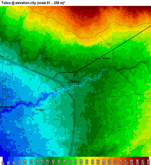
Below is the Elevation map of Telica, which displays elevation range with different colors. Scale of the first map is from 81 to 258 m (266 to 846 ft) with average elevation of 149.7 meters (=491 ft) [note 1]
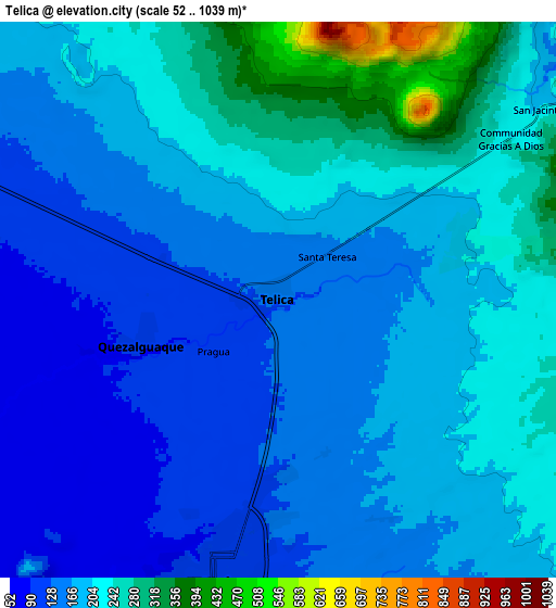
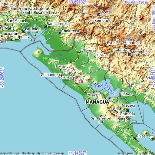
These maps also provides idea of topography and contour of this city, they are displayed at different zoom levels. More info about maps, scale and edge coordinates you can find below images.
| \ | Map #1 | Map #2 | Topo.Map |
| Scale [m] | 81..258 m | 52..1039 m | × |
| Scale [ft] | 266..846 ft | 171..3409 ft | × |
| Average | 149.7 m = 491 ft | 188.6 m = 619 ft | × |
| Width | 9.54 km = 5.9 mi | 19.08 km = 11.9 mi | 305.3 km = 189.7 mi |
| Height | 9.54 km = 5.9 mi | 19.08 km = 11.9 mi | 305.3 km = 189.7 mi |
| ↑Max Latitude | 12.564896° | 12.607786° | 13.89102° |
| Latitude at center | 12.522° | 12.522° | 12.522° |
| ↓Min Latitude | 12.479096° | 12.436186° | 11.14567° |
| ← Min Longitude | -86.903325° | -86.947271° | -88.26563° |
| Longitude center | -86.85938° | -86.85938° | -86.85938° |
| →Max Longitude | -86.815435° | -86.771489° | -85.45313° |
Nearby cities:
Cities around Telica sort by population:
• León elevation 107 m
9.6 km,  192°
192°
• Chinandega 69 m
31.8 km,  292°
292°
• El Viejo 47 m
36.9 km,  295°
295°
• Chichigalpa 89 m
19.2 km, 288°
• La Paz Centro 73 m
28.4 km,  135°
135°
• Corinto 8 m
34.3 km,  262°
262°
• Larreynaga 97 m
35.6 km,  61°
61°
• Posoltega 76 m
13.3 km,  280°
280°
• El Realejo 11 m
33.3 km,  274°
274°
• Quezalguaque 98 m
5 km,  250°
250°
• Tonalá 33 m
40.3 km,  312°
312°
• Malpaisillo 119 m
21.1 km,  67°
67°
Multilingual:
 En español:
Telica elevación 131 m.
 En France:
Telica élévation 131 m.


Sources and notes:
- [note 1] Map square and city borders are not equal. Map elevation data is calculated only from area inside that square.
- [src 1] Elevation data from geonames database provided with same terms of usage.
- [src 2] The elevation map of Telica is generated using elevation data from NASA's 3 arcsec (90m) resolution SRTM data.
- [src 3] Base (background) map © OpenStreetMap contributors tiles are generated by Geofabrik and OpenTopoMap.
Copyright & License:
This Telica Elevation Map is licensed under CC BY-SA. You may reuse any part from this page, if you give a proper credit by linking to this URL:
 More info on terms of use page.