Teustepe elevation
Teustepe (Boaco), Nicaragua elevation is 155 meters and Teustepe elevation in feet is 509 ft above sea level [src 1]. Teustepe is a seat of a second-order administrative division (feature code) with elevation that is 186 meters (610 ft) smaller than average city elevation in Nicaragua.
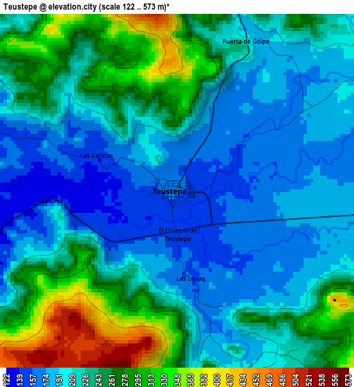
Below is the Elevation map of Teustepe, which displays elevation range with different colors. Scale of the first map is from 122 to 573 m (400 to 1880 ft) with average elevation of 229 meters (=751 ft) [note 1]
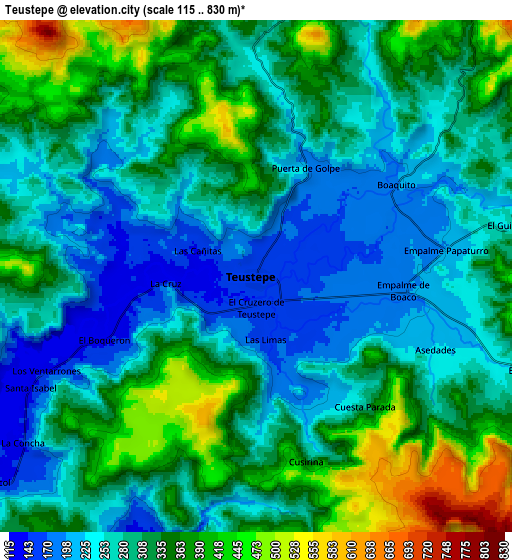
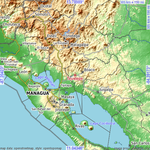
These maps also provides idea of topography and contour of this city, they are displayed at different zoom levels. More info about maps, scale and edge coordinates you can find below images.
| \ | Map #1 | Map #2 | Topo.Map |
| Scale [m] | 122..573 m | 115..830 m | × |
| Scale [ft] | 400..1880 ft | 377..2723 ft | × |
| Average | 229 m = 751 ft | 307.2 m = 1008 ft | × |
| Width | 9.54 km = 5.9 mi | 19.09 km = 11.9 mi | 305.4 km = 189.8 mi |
| Height | 9.54 km = 5.9 mi | 19.09 km = 11.9 mi | 305.4 km = 189.8 mi |
| ↑Max Latitude | 12.463213° | 12.506119° | 13.78989° |
| Latitude at center | 12.4203° | 12.4203° | 12.4203° |
| ↓Min Latitude | 12.37738° | 12.334452° | 11.04346° |
| ← Min Longitude | -85.841925° | -85.885871° | -87.20423° |
| Longitude center | -85.79798° | -85.79798° | -85.79798° |
| →Max Longitude | -85.754035° | -85.710089° | -84.39173° |
Nearby cities:
Cities around Teustepe sort by population:
• Tipitapa elevation 54 m
40.9 km,  232°
232°
• Boaco 380 m
16.2 km,  69°
69°
• Camoapa 571 m
31.2 km,  97°
97°
• San Lorenzo 381 m
15 km,  108°
108°
• Tisma 53 m
44.5 km,  212°
212°
• Muy Muy 340 m
42.2 km,  25°
25°
• San Dionisio 383 m
38.2 km,  351°
351°
• San José de los Remates 678 m
20.1 km,  11°
11°
• Terrabona 538 m
38.9 km,  332°
332°
• Santa Lucía 553 m
15.7 km,  37°
37°
• Comalapa 273 m
34.7 km,  116°
116°
• Esquipulas 522 m
27.2 km,  2°
2°
Multilingual:
 En español:
Teustepe elevación 155 m.
 En France:
Teustepe élévation 155 m.
 Auf Deutsch:
Teustepe höhe über dem Meeresspiegel ist 155 m.

Sources and notes:
- [note 1] Map square and city borders are not equal. Map elevation data is calculated only from area inside that square.
- [src 1] Elevation data from geonames database provided with same terms of usage.
- [src 2] The elevation map of Teustepe is generated using elevation data from NASA's 3 arcsec (90m) resolution SRTM data.
- [src 3] Base (background) map © OpenStreetMap contributors tiles are generated by Geofabrik and OpenTopoMap.
Copyright & License:
This Teustepe Elevation Map is licensed under CC BY-SA. You may reuse any part from this page, if you give a proper credit by linking to this URL:
 More info on terms of use page.