Waslala elevation
Waslala (North Caribbean Coast), Nicaragua elevation is 316 meters and Waslala elevation in feet is 1037 ft above sea level [src 1]. Waslala is a populated place (feature code) with elevation that is 25 meters (82 ft) smaller than average city elevation in Nicaragua.
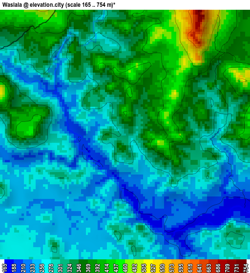
Below is the Elevation map of Waslala, which displays elevation range with different colors. Scale of the first map is from 165 to 754 m (541 to 2474 ft) with average elevation of 309.7 meters (=1016 ft) [note 1]
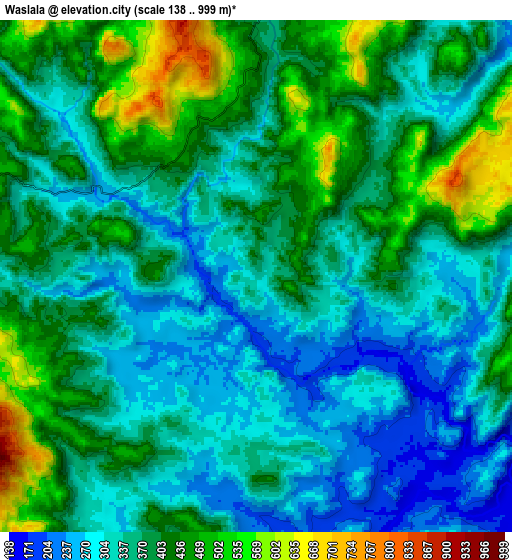
These maps also provides idea of topography and contour of this city, they are displayed at different zoom levels. More info about maps, scale and edge coordinates you can find below images.
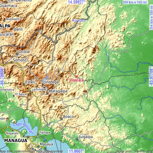
| \ | Map #1 | Map #2 | Topo.Map |
| Scale [m] | 165..754 m | 138..999 m | × |
| Scale [ft] | 541..2474 ft | 453..3278 ft | × |
| Average | 309.7 m = 1016 ft | 370.8 m = 1217 ft | × |
| Width | 9.51 km = 5.9 mi | 19.03 km = 11.8 mi | 304.4 km = 189.1 mi |
| Height | 9.51 km = 5.9 mi | 19.03 km = 11.8 mi | 304.4 km = 189.1 mi |
| ↑Max Latitude | 13.276105° | 13.318872° | 14.59827° |
| Latitude at center | 13.23333° | 13.23333° | 13.23333° |
| ↓Min Latitude | 13.190548° | 13.147758° | 11.8607° |
| ← Min Longitude | -85.427275° | -85.471221° | -86.78958° |
| Longitude center | -85.38333° | -85.38333° | -85.38333° |
| →Max Longitude | -85.339385° | -85.295439° | -83.97708° |
Nearby cities:
Cities around Waslala sort by population:
• Río Blanco elevation 265 m
37.5 km,  152°
152°
• Matiguás 300 m
44.9 km,  190°
190°
• Bocana de Paiwas 146 m
57.2 km, 150°
• Las Praderas 1009 m
51 km,  262°
262°
• Muy Muy 340 m
58.8 km,  206°
206°
• San José de Bocay 305 m
38.3 km,  333°
333°
• Mulukukú 87 m
46.8 km,  97°
97°
• El Cuá 508 m
44.6 km,  297°
297°
• La Dalia 741 m
39.8 km,  254°
254°
• El Cuá 439 m
34.8 km, 295°
• Rancho Grande 616 m
18.9 km,  271°
271°
• Waslala 376 m
11.5 km,  6°
6°
Multilingual:
 En español:
Waslala elevación 316 m.
 En France:
Waslala élévation 316 m.


Sources and notes:
- [note 1] Map square and city borders are not equal. Map elevation data is calculated only from area inside that square.
- [src 1] Elevation data from geonames database provided with same terms of usage.
- [src 2] The elevation map of Waslala is generated using elevation data from NASA's 3 arcsec (90m) resolution SRTM data.
- [src 3] Base (background) map © OpenStreetMap contributors tiles are generated by Geofabrik and OpenTopoMap.
Copyright & License:
This Waslala Elevation Map is licensed under CC BY-SA. You may reuse any part from this page, if you give a proper credit by linking to this URL:
 More info on terms of use page.