Matiguás elevation
Matiguás (Matagalpa), Nicaragua elevation is 300 meters and Matiguás elevation in feet is 984 ft above sea level [src 1]. Matiguás is a seat of a second-order administrative division (feature code) with elevation that is 41 meters (135 ft) smaller than average city elevation in Nicaragua.
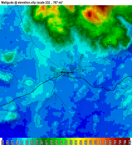
Below is the Elevation map of Matiguás, which displays elevation range with different colors. Scale of the first map is from 232 to 767 m (761 to 2516 ft) with average elevation of 325.4 meters (=1068 ft) [note 1]
These maps also provides idea of topography and contour of this city, they are displayed at different zoom levels. More info about maps, scale and edge coordinates you can find below images.
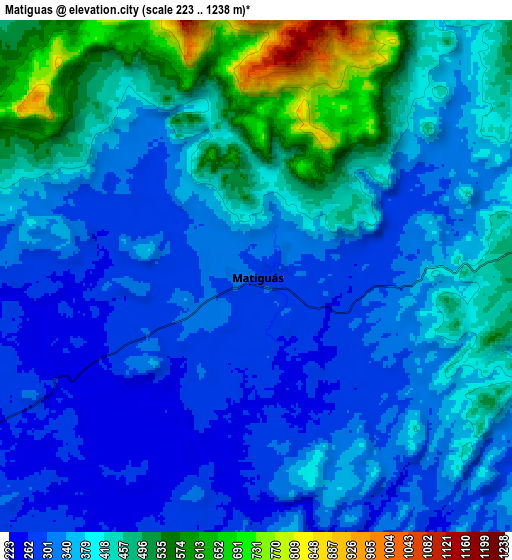
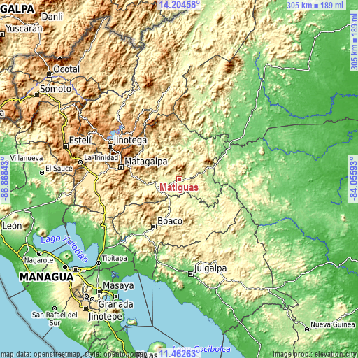
| \ | Map #1 | Map #2 | Topo.Map |
| Scale [m] | 232..767 m | 223..1238 m | × |
| Scale [ft] | 761..2516 ft | 732..4062 ft | × |
| Average | 325.4 m = 1068 ft | 386.4 m = 1268 ft | × |
| Width | 9.53 km = 5.9 mi | 19.06 km = 11.8 mi | 304.9 km = 189.5 mi |
| Height | 9.53 km = 5.9 mi | 19.06 km = 11.8 mi | 304.9 km = 189.5 mi |
| ↑Max Latitude | 12.880183° | 12.923019° | 14.20458° |
| Latitude at center | 12.83734° | 12.83734° | 12.83734° |
| ↓Min Latitude | 12.794489° | 12.751632° | 11.46263° |
| ← Min Longitude | -85.506125° | -85.550071° | -86.86843° |
| Longitude center | -85.46218° | -85.46218° | -85.46218° |
| →Max Longitude | -85.418235° | -85.374289° | -84.05593° |
Nearby cities:
Cities around Matiguás sort by population:
• Boaco elevation 380 m
45.8 km,  207°
207°
• Río Blanco 265 m
28 km,  67°
67°
• Bocana de Paiwas 146 m
37.3 km,  98°
98°
• Waslala 316 m
44.9 km,  10°
10°
• Muy Muy 340 m
19.9 km,  245°
245°
• San Dionisio 383 m
42.9 km,  258°
258°
• San Ramón 639 m
41.9 km,  283°
283°
• San José de los Remates 678 m
42 km,  230°
230°
• Santa Lucía 553 m
43.3 km,  218°
218°
• Rancho Grande 616 m
45.6 km,  346°
346°
• La Dalia 741 m
44.7 km,  318°
318°
• Esquipulas 522 m
40.2 km,  241°
241°
Multilingual:
 En español:
Matiguás elevación 300 m.
 En France:
Matiguás élévation 300 m.
 Auf Deutsch:
Matiguás höhe über dem Meeresspiegel ist 300 m.

Sources and notes:
- [note 1] Map square and city borders are not equal. Map elevation data is calculated only from area inside that square.
- [src 1] Elevation data from geonames database provided with same terms of usage.
- [src 2] The elevation map of Matiguás is generated using elevation data from NASA's 3 arcsec (90m) resolution SRTM data.
- [src 3] Base (background) map © OpenStreetMap contributors tiles are generated by Geofabrik and OpenTopoMap.
Copyright & License:
This Matiguás Elevation Map is licensed under CC BY-SA. You may reuse any part from this page, if you give a proper credit by linking to this URL:
 More info on terms of use page.