El Cuá elevation
El Cuá (Jinotega, Municipio El Cua), Nicaragua elevation is 508 meters and El Cuá elevation in feet is 1667 ft above sea level [src 1]. El Cuá is a seat of a second-order administrative division (feature code) with elevation that is 167 meters (548 ft) bigger than average city elevation in Nicaragua.
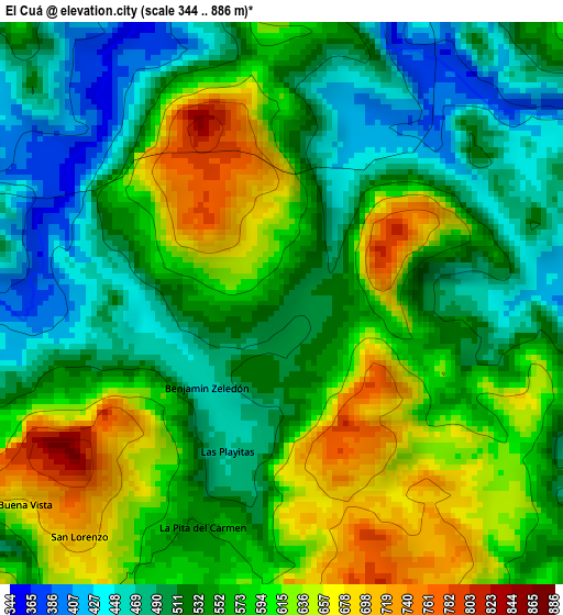
Below is the Elevation map of El Cuá, which displays elevation range with different colors. Scale of the first map is from 344 to 886 m (1129 to 2907 ft) with average elevation of 558 meters (=1831 ft) [note 1]
These maps also provides idea of topography and contour of this city, they are displayed at different zoom levels. More info about maps, scale and edge coordinates you can find below images.
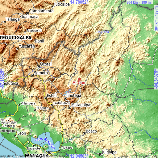
| \ | Map #1 | Topo.Map |
| Scale [m] | 344..886 m | × |
| Scale [ft] | 1129..2907 ft | × |
| Average | 558 m = 1831 ft | × |
| Width | 9.51 km = 5.9 mi | 304.2 km = 189 mi |
| Height | 9.51 km = 5.9 mi | 304.2 km = 189 mi |
| ↑Max Latitude | 13.459412° | 14.78052° |
| Latitude at center | 13.41667° | 13.41667° |
| ↓Min Latitude | 13.37392° | 12.04503° |
| ← Min Longitude | -85.793945° | -87.15625° |
| Longitude center | -85.75° | -85.75° |
| →Max Longitude | -85.706055° | -84.34375° |
Nearby cities:
Cities around El Cuá sort by population:
• Quilalí elevation 412 m
34.2 km,  299°
299°
• Las Praderas 1009 m
29.5 km,  201°
201°
• Wiwilí 313 m
24.7 km,  340°
340°
• San José de Bocay 305 m
26.7 km,  58°
58°
• LLano de La Cruz 980 m
42.9 km,  220°
220°
• Waslala 376 m
42 km,  102°
102°
• La Dalia 741 m
31.2 km,  177°
177°
• Rancho Grande 616 m
28.8 km,  133°
133°
• Wiwili 301 m
23.9 km, 340°
• Wiwilí de Jinotega 339 m
23.2 km, 341°
• Santa Maía de Pantasma 404 m
22.4 km,  250°
250°
• El Cuá 439 m
9.9 km,  122°
122°
Multilingual:
 En español:
El Cuá elevación 508 m.
 En France:
El Cuá élévation 508 m.


Sources and notes:
- [note 1] Map square and city borders are not equal. Map elevation data is calculated only from area inside that square.
- [src 1] Elevation data from geonames database provided with same terms of usage.
- [src 2] The elevation map of El Cuá is generated using elevation data from NASA's 3 arcsec (90m) resolution SRTM data.
- [src 3] Base (background) map © OpenStreetMap contributors tiles are generated by Geofabrik and OpenTopoMap.
Copyright & License:
This El Cuá Elevation Map is licensed under CC BY-SA. You may reuse any part from this page, if you give a proper credit by linking to this URL:
 More info on terms of use page.