Quilalí elevation
Quilalí (Nueva Segovia), Nicaragua elevation is 412 meters and Quilalí elevation in feet is 1352 ft above sea level [src 1]. Quilalí is a seat of a second-order administrative division (feature code) with elevation that is 71 meters (233 ft) bigger than average city elevation in Nicaragua.
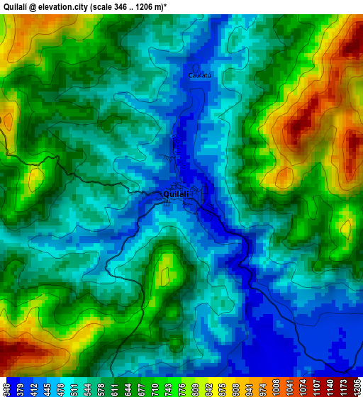
Below is the Elevation map of Quilalí, which displays elevation range with different colors. Scale of the first map is from 346 to 1206 m (1135 to 3957 ft) with average elevation of 610.6 meters (=2003 ft) [note 1]
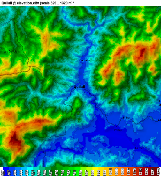
These maps also provides idea of topography and contour of this city, they are displayed at different zoom levels. More info about maps, scale and edge coordinates you can find below images.
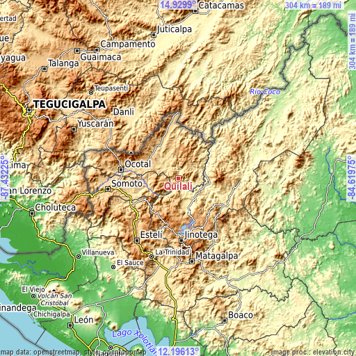
| \ | Map #1 | Map #2 | Topo.Map |
| Scale [m] | 346..1206 m | 329..1329 m | × |
| Scale [ft] | 1135..3957 ft | 1079..4360 ft | × |
| Average | 610.6 m = 2003 ft | 637.7 m = 2092 ft | × |
| Width | 9.5 km = 5.9 mi | 19 km = 11.8 mi | 304 km = 188.9 mi |
| Height | 9.5 km = 5.9 mi | 19 km = 11.8 mi | 304 km = 188.9 mi |
| ↑Max Latitude | 13.609665° | 13.652373° | 14.9299° |
| Latitude at center | 13.56695° | 13.56695° | 13.56695° |
| ↓Min Latitude | 13.524227° | 13.481496° | 12.19613° |
| ← Min Longitude | -86.069945° | -86.113891° | -87.43225° |
| Longitude center | -86.026° | -86.026° | -86.026° |
| →Max Longitude | -85.982055° | -85.938109° | -84.61975° |
Nearby cities:
Cities around Quilalí sort by population:
• Wiwilí elevation 313 m
22.7 km,  72°
72°
• San Sebastián de Yalí 855 m
33.9 km,  210°
210°
• San Fernando 733 m
33.5 km,  291°
291°
• San Juan de Río Coco 822 m
15.2 km,  260°
260°
• Telpaneca 499 m
28.5 km, 262°
• Ciudad Antigua 634 m
31.6 km, 285°
• Murra 776 m
21.3 km,  2°
2°
• El Cuá 508 m
34.2 km,  119°
119°
• Santa Maía de Pantasma 404 m
25.9 km,  160°
160°
• Wiwilí de Jinotega 339 m
23.2 km,  76°
76°
• Wiwili 301 m
22.5 km, 75°
• El Jícaro 543 m
21.2 km,  324°
324°
Multilingual:
 En español:
Quilalí elevación 412 m.
 En France:
Quilalí élévation 412 m.


Sources and notes:
- [note 1] Map square and city borders are not equal. Map elevation data is calculated only from area inside that square.
- [src 1] Elevation data from geonames database provided with same terms of usage.
- [src 2] The elevation map of Quilalí is generated using elevation data from NASA's 3 arcsec (90m) resolution SRTM data.
- [src 3] Base (background) map © OpenStreetMap contributors tiles are generated by Geofabrik and OpenTopoMap.
Copyright & License:
This Quilalí Elevation Map is licensed under CC BY-SA. You may reuse any part from this page, if you give a proper credit by linking to this URL:
 More info on terms of use page.