Mabudi elevation
Mabudi (Plateau, Langtang South), Nigeria elevation is 199 meters and Mabudi elevation in feet is 653 ft above sea level [src 1]. Mabudi is a seat of a second-order administrative division (feature code) with elevation that is 98 meters (322 ft) smaller than average city elevation in Nigeria.
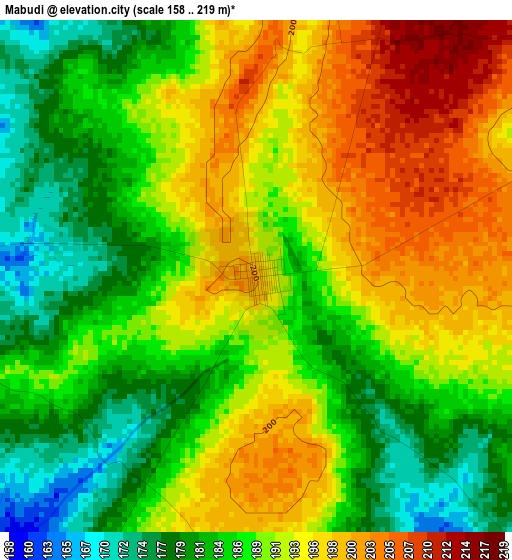
Below is the Elevation map of Mabudi, which displays elevation range with different colors. Scale of the first map is from 158 to 219 m (518 to 719 ft) with average elevation of 189.4 meters (=621 ft) [note 1]
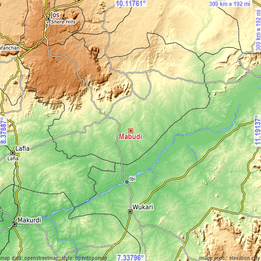
These maps also provides idea of topography and contour of this city, they are displayed at different zoom levels. More info about maps, scale and edge coordinates you can find below images.
| \ | Map #1 | Topo.Map |
| Scale [m] | 158..219 m | × |
| Scale [ft] | 518..719 ft | × |
| Average | 189.4 m = 621 ft | × |
| Width | 9.66 km = 6 mi | 309.1 km = 192.1 mi |
| Height | 9.66 km = 6 mi | 309.1 km = 192.1 mi |
| ↑Max Latitude | 8.773804° | 10.11761° |
| Latitude at center | 8.73037° | 8.73037° |
| ↓Min Latitude | 8.686931° | 7.33796° |
| ← Min Longitude | 9.741175° | 8.37887° |
| Longitude center | 9.78512° | 9.78512° |
| →Max Longitude | 9.829065° | 11.19137° |
Nearby cities:
Cities around Mabudi sort by population:
• Ibi elevation 109 m
61.2 km,  184°
184°
• Gassol 132 m
75.8 km,  106°
106°
• Yelwa 221 m
20.2 km,  304°
304°
• Langtang 328 m
45.7 km,  0°
0°
• Amper 461 m
70.1 km,  352°
352°
• Kwolla 269 m
57.6 km,  289°
289°
• Dengi 384 m
73.6 km,  15°
15°
• Kwal 667 m
73.6 km, 345°
• Baap 299 m
64.3 km, 291°
• Wase 251 m
44.6 km, 24°
• Tunkus 294 m
37.5 km,  329°
329°
• Shendam 201 m
32.1 km, 300°
Multilingual:
 En español:
Mabudi elevación 199 m.
 En France:
Mabudi élévation 199 m.


Sources and notes:
- [note 1] Map square and city borders are not equal. Map elevation data is calculated only from area inside that square.
- [src 1] Elevation data from geonames database provided with same terms of usage.
- [src 2] The elevation map of Mabudi is generated using elevation data from NASA's 3 arcsec (90m) resolution SRTM data.
- [src 3] Base (background) map © OpenStreetMap contributors tiles are generated by Geofabrik and OpenTopoMap.
Copyright & License:
This Mabudi Elevation Map is licensed under CC BY-SA. You may reuse any part from this page, if you give a proper credit by linking to this URL:
 More info on terms of use page.