Ibi elevation
Ibi (Taraba), Nigeria elevation is 109 meters and Ibi elevation in feet is 358 ft above sea level [src 1]. Ibi is a seat of a second-order administrative division (feature code) with elevation that is 188 meters (617 ft) smaller than average city elevation in Nigeria.
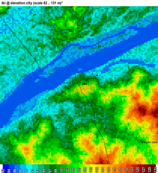
Below is the Elevation map of Ibi, which displays elevation range with different colors. Scale of the first map is from 82 to 131 m (269 to 430 ft) with average elevation of 97.8 meters (=321 ft) [note 1]
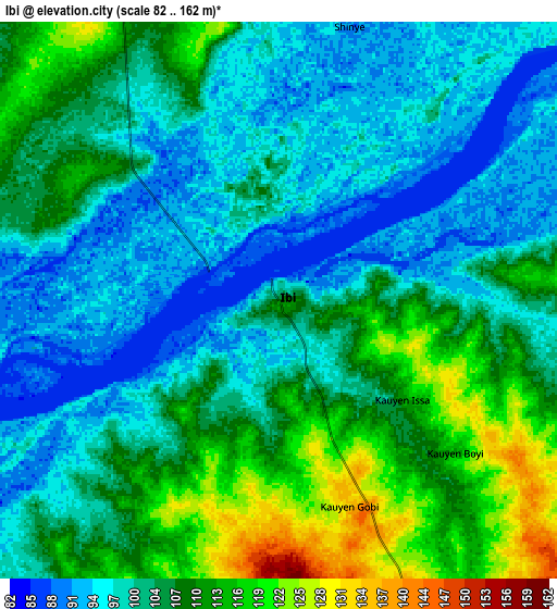
These maps also provides idea of topography and contour of this city, they are displayed at different zoom levels. More info about maps, scale and edge coordinates you can find below images.
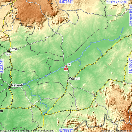
| \ | Map #1 | Map #2 | Topo.Map |
| Scale [m] | 82..131 m | 82..162 m | × |
| Scale [ft] | 269..430 ft | 269..531 ft | × |
| Average | 97.8 m = 321 ft | 103.9 m = 341 ft | × |
| Width | 9.67 km = 6 mi | 19.35 km = 12 mi | 309.5 km = 192.3 mi |
| Height | 9.67 km = 6 mi | 19.35 km = 12 mi | 309.5 km = 192.3 mi |
| ↑Max Latitude | 8.224716° | 8.268207° | 9.57059° |
| Latitude at center | 8.18122° | 8.18122° | 8.18122° |
| ↓Min Latitude | 8.13772° | 8.094214° | 6.78699° |
| ← Min Longitude | 9.700365° | 9.656419° | 8.33806° |
| Longitude center | 9.74431° | 9.74431° | 9.74431° |
| →Max Longitude | 9.788255° | 9.832201° | 11.15056° |
Nearby cities:
Cities around Ibi sort by population:
• Wukari elevation 189 m
34.6 km,  173°
173°
• Gassol 132 m
86.7 km,  62°
62°
• Yelwa 221 m
73.5 km,  350°
350°
• Zaki Biam 204 m
76.4 km,  191°
191°
• Kwolla 269 m
94.5 km,  328°
328°
• Riti 127 m
33.4 km,  204°
204°
• Ugba 189 m
86.7 km,  210°
210°
• Shendam 201 m
80.9 km,  343°
343°
• Sankera 208 m
72.5 km, 188°
• Awe 120 m
67 km,  262°
262°
• Mabudi 199 m
61.2 km,  4°
4°
• Donga 136 m
60.9 km,  147°
147°
Multilingual:
 En español:
Ibi elevación 109 m.
 En France:
Ibi élévation 109 m.


Sources and notes:
- [note 1] Map square and city borders are not equal. Map elevation data is calculated only from area inside that square.
- [src 1] Elevation data from geonames database provided with same terms of usage.
- [src 2] The elevation map of Ibi is generated using elevation data from NASA's 3 arcsec (90m) resolution SRTM data.
- [src 3] Base (background) map © OpenStreetMap contributors tiles are generated by Geofabrik and OpenTopoMap.
Copyright & License:
This Ibi Elevation Map is licensed under CC BY-SA. You may reuse any part from this page, if you give a proper credit by linking to this URL:
 More info on terms of use page.