Bama elevation
Bama (Borno), Nigeria elevation is 330 meters and Bama elevation in feet is 1083 ft above sea level [src 1]. Bama is a seat of a second-order administrative division (feature code) with elevation that is 33 meters (108 ft) bigger than average city elevation in Nigeria.
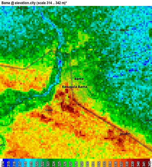
Below is the Elevation map of Bama, which displays elevation range with different colors. Scale of the first map is from 314 to 342 m (1030 to 1122 ft) with average elevation of 326.4 meters (=1071 ft) [note 1]
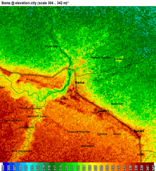
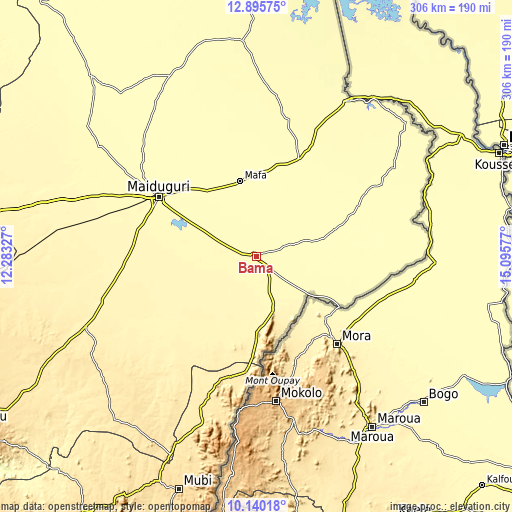
These maps also provides idea of topography and contour of this city, they are displayed at different zoom levels. More info about maps, scale and edge coordinates you can find below images.
| \ | Map #1 | Map #2 | Topo.Map |
| Scale [m] | 314..342 m | 304..342 m | × |
| Scale [ft] | 1030..1122 ft | 997..1122 ft | × |
| Average | 326.4 m = 1071 ft | 325.6 m = 1068 ft | × |
| Width | 9.58 km = 6 mi | 19.15 km = 11.9 mi | 306.4 km = 190.4 mi |
| Height | 9.58 km = 6 mi | 19.15 km = 11.9 mi | 306.4 km = 190.4 mi |
| ↑Max Latitude | 11.564397° | 11.607446° | 12.89575° |
| Latitude at center | 11.52134° | 11.52134° | 11.52134° |
| ↓Min Latitude | 11.478277° | 11.435207° | 10.14018° |
| ← Min Longitude | 13.645575° | 13.601629° | 12.28327° |
| Longitude center | 13.68952° | 13.68952° | 13.68952° |
| →Max Longitude | 13.733465° | 13.777411° | 15.09577° |
Nearby cities:
Cities around Bama sort by population:
• Maiduguri elevation 325 m
68.3 km,  301°
301°
• Dikwa 298 m
62.4 km,  23°
23°
• Marte 292 m
95.1 km,  9°
9°
• Gwoza 418 m
48.7 km,  179°
179°
• Ngala 294 m
105.9 km,  30°
30°
• Konduga 330 m
33 km, 296°
• Madagali 503 m
70.6 km,  185°
185°
• Tokombere 360 m
39.9 km,  213°
213°
• Michika 528 m
105.4 km,  198°
198°
• Gulak 488 m
83.5 km, 197°
• Khaddamari 311 m
67.2 km,  311°
311°
• Mafa 306 m
45.8 km,  347°
347°
Multilingual:
 En español:
Bama elevación 330 m.
 En France:
Bama élévation 330 m.


Sources and notes:
- [note 1] Map square and city borders are not equal. Map elevation data is calculated only from area inside that square.
- [src 1] Elevation data from geonames database provided with same terms of usage.
- [src 2] The elevation map of Bama is generated using elevation data from NASA's 3 arcsec (90m) resolution SRTM data.
- [src 3] Base (background) map © OpenStreetMap contributors tiles are generated by Geofabrik and OpenTopoMap.
Copyright & License:
This Bama Elevation Map is licensed under CC BY-SA. You may reuse any part from this page, if you give a proper credit by linking to this URL:
 More info on terms of use page.